Mawahib kamal alhaj1, Ashraf Gasim Elsid Abdalla 2
1Postgraduates school, Al neleen University, Khartoum, Sudan
Kmawahib888@gmail.com
2School of electronic, College of Engineering, Sudan University of Science and Technology
agea33@yahoo.com; drashraf@sustech.net, www.sust.edu :
HNSJ, 2022, 3(11); https://doi.org/10.53796/hnsj3116
Published at 01/11/2022 Accepted at 06/10/2022
Abstract
These days, governmental and private institutions face many challenges in the fields of service management and emergency and crisis management (transportation, roads, communications, water and electricity, urban planning, transportation, … etc) . These challenges are represented in providing quick and accurate information that helps managers making decisions for daily matters, managing resources and future planning, as well as managing crises and disasters and dealing with emergencies, which led to thinking seriously about creating programs that have the characteristics of providing information accurately and easily and linking them to services to help the decision maker, Geographic information systems provide that. This paper reviews a group of researches in various areas of services, in which researchers used geographic information systems to address problems and find appropriate solution. As the geographic information systems are distinguished by the ability to create huge data bases and link them to the phenomenon (the field of service) in a spatial manner (the location on the map of the service). The researchers recommends in the future to use the geographic information systems programs in the techniques of managing and distributing services because of its huge potential in presenting problems and shortcomings and providing ideal solutions.
Key Words: transports , system management , system planning , design support , GIS system
[1] Introduction:
The use of geographic information systems has developed in many areas of service distribution (transport, roads, communications, water and electricity, urban planning, transportation, … etc.).This is because of its advantage in visualizing the service (the phenomenon) in the form of maps and databases with huge capabilities and linking them to the geographical location on the surface of the earth, which contributes to reading the present and future reality and taking the correct decisions and procedures to reach the appropriate solutions in the least law and with the least effort and cost.
[2] Geographic information systems in public transport and roads:
In the Kingdom of Saudi Arabia, the researcher Abdullah bin Muhammad Al-Qarni studied the uses of geographic information systems in good traffic management on long roads. As the road networks in the Kingdom of Saudi Arabia have accelerated during the past five decades, The research problem is summarized in the establishment of a network of main (long) paved roads to connect the main regions in the Kingdom and good traffic management in them with safety and security, to serve the largest number of cities, villages and population centers in various parts of the Kingdom To achieve this, proper planning and conscious studies were required that take the latest methods reached by the world to build road networks as quickly as possible and with the least amount of costs, so that the kingdom starts from where the others ended. The research aims to connect the main areas in the Kingdom with a network of asphalted roads, and then Developing this network, developing the level of services on it, providing safety means on it, and activating geographic information systems in the road and express traffic sectors, starting with planning, designing, implementing, monitoring and controlling in long roads, and activating them in the areas of traffic and safety as figure1.The research presented a simplified presentation of the great development witnessed by highways in the Kingdom of Saudi Arabia, the problems facing officials in developing road networks, and the role that GIS and their support systems offer to solve traffic management problems on long roads, as it has become one of the most important decision support systems in the world that we cannot do without In the areas of rapid development that we are witnessing today. The role of geographic information systems and global positioning systems (GPS) is not limited to planning cities and infrastructures, but also to make their role widely and di stinct in the field of transportation, roads and traffic. [1]
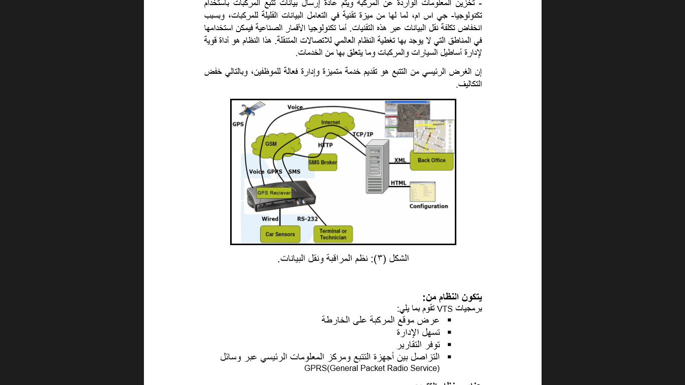
Figure 1: Monitoring and Data Transmission in Transport System
In the People’s Democratic Republic of Algeria, the researcher Hoda Daghfal studied the use of geographic information systems in preparing the traffic and traffic plan for the city of Al-Musaliya. Whereas, the research problem is crystallized in the great challenges that Algerian cities face in the field of managing services and transport by developing methods that ensure the efficiency of management, relying on daily movement and transport plans and linking these data with spatial features, carrying out downloads, questioning and making graphic charts. This is what made us ask what is the role of geographic information systems in planning movement and traffic within the city?. The study aims to highlight the importance of applying scientific methods in traffic and traffic planning, in particular, by using the technical factor in the process of studying the reality of the status of basic structures and movement and traffic through the use of computer technologies, creating a database on the various elements of the traffic and traffic scheme in the city, identifying defects and supporting good planning and good distribution using systems Geographic information and the use of an integrated system in the field of transportation, movement and traffic. It was concluded that the major benefit of traffic planning ensures the safe movement of people and goods and serves the achievement of the highest goal of society, which is ease of access and movement within the city, alleviating traffic problems in the city center and keeping pace with technological development as figure 2. [2]
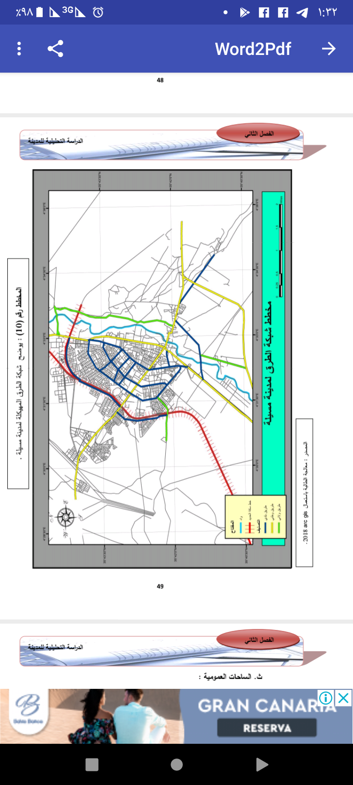
Figure2: Road net work of Musaliya
In the United Kingdom, in the city of London, researchers Stuart L. Barr, Richard J. Dawson, and Philip James studied and analyzed ease of transportation using geographic information systems, as the importance of the study stems from the fact that accessibility through transportation is an important driver of urban growth and the key to sustainable development of cities. The research aims to develop a simple tool that relies on geographic information systems to allow rapid analysis of accessibility by different means of transport, and this tool is designed to be flexible and that the use of data in it is available to the public (inquiry screens and display maps), and this tool uses generalized cost to measure transportation costs across networks including In it the monetary and distance components. As it can be used to display the different modes of arrival throughout the city through different modes of transport, and it has been proven that these patterns can be examined spatially, by reaching specific destinations (for example work sites, employment … etc), as well as being able to test A number of future infrastructure scenarios, and a study of the possibility of increasing the use of low-carbon forms of transportation. The following conclusions were reached: The use of this tool provides spatial maps, generalized cost and accessibility, and enables decision-makers to quickly assess the impacts and developments of the new infrastructure on accessibility on a local scale and compare access patterns with each other. It is also possible to analyze networks of different modes of transport, and to explore the large spatial variation in transport and labor costs, highlighting that investment may be required in low-carbon forms of transportation. Rapid analysis of accessibility patterns helps to explore a wide range of possible transportation options and balance factors such as maintaining access to work and ensuring connectivity for residential areas. The tool allows rapid assessment when transport analysis is included in multi-sector analyzes so that investment in transportation infrastructure can be assessed alongside Other investments are towards building a balanced portfolio of options that can assist in urban development as figure3. [3]
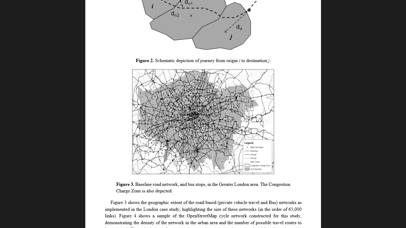
Figure 3. Baseline road network, and bus stops, in the Greater London area.
In the Km of Saudi Arabia, researcher Amer bin Nasser Al-Mutair studied the reality of public transport by private buses and took a case study (Riyadh) , The research problem revolves around the population increase that occurred in the main cities of the Kingdom of Saudi Arabia, especially the city of Riyadh, which led to traffic jams and traffic density on the main roads. As it relies heavily on the private car for transportation, and public transport does not contribute to the movement of transportation within the city of Riyadh by more than 2%. The current state of public transport in the city of Riyadh does not have a clear identity in that it is a real public transport system that can be relied upon as a major transporter for movement within the city. The research aims to identify the reality of public transport in the city of Riyadh and the characteristics of public transport by buses in terms of the type of buses used on the lines, the routes within the city and its various neighborhoods, as well as the opinions of private bus drivers and the opinions of the users of this means as in figure 4. The research found that public transport by public buses contributes by 2% to the transportation system within the city, and that public transport is carried out by a large percentage of private buses (owned by individuals). The general public is in the city and not investing in it. the author has submitted his recommendations to the city administration to address deficiencies, overcome obstacles, and encourage investment by the government in the public transport system in the city.[4]
Figure4: Riyadh transport system
In Australia, the researcher “Brown” studied the environmental modeling system based on geographic information systems for transport planners, where a system based on geographic information systems and environmental modeling “TRAEMS” was programmed. The research aims to use the capabilities of geographic information systems to integrate the output from the transportation planning activity with information about land use to model the environmental impacts of various road traffic scenarios. TRAEMS enables planners to test transportation and related environmental impacts at the same time because it is a test that carries proficiency in network planning. The results of the research revealed the suitability of this type of environmental modeling for planning purposes, as this system has been utilized and used by transport planners in assessing the environmental impacts of traffic plans now and in the future.[5]
In Libya – Tripoli, the researcher M. Hussein Ayad Al-Majdoub studies the use of geographic information systems in analyzing and managing road networks. Where the research problem is summarized in: Road networks management is considered one of the most important and driving areas for urban and economic growth due to the connection of many areas of growth in this area, and since the management of these networks requires the availability of a lot of information that must be organized according to work requirements in order for the administration to be optimized It is necessary and most appropriate to deal with this data through a tool that enables us to contain this information for road management. The research aims to use geographic information systems in preparing a digital system for road networks and linking them with service information to determine the most appropriate road between two points in terms of distance and time. Which, in turn, will reduce the losses resulting from the risks of accidents and fires by choosing the appropriate paths to speed up access to the places of fires and accidents to reduce the material and human losses, and to identify the most appropriate sites for establishing emergency points such as the distribution of ambulances and civil defense and the establishment of service areas such as the distribution of police stations and hospitals. It was concluded that the use of geographic information systems enables the optimal use of road networks to reach the sites of various service centers. It is considered the best solution to eliminate road problems that include accidents, congestion, and bottlenecks at certain points and at different times. And that by dealing with digital information. It also enables proper engineering planning for future projects and speeding up various services. This system is a central digital database that relies on exchanging information on methods that can be used in most other sectors of the country as figures5.[6]
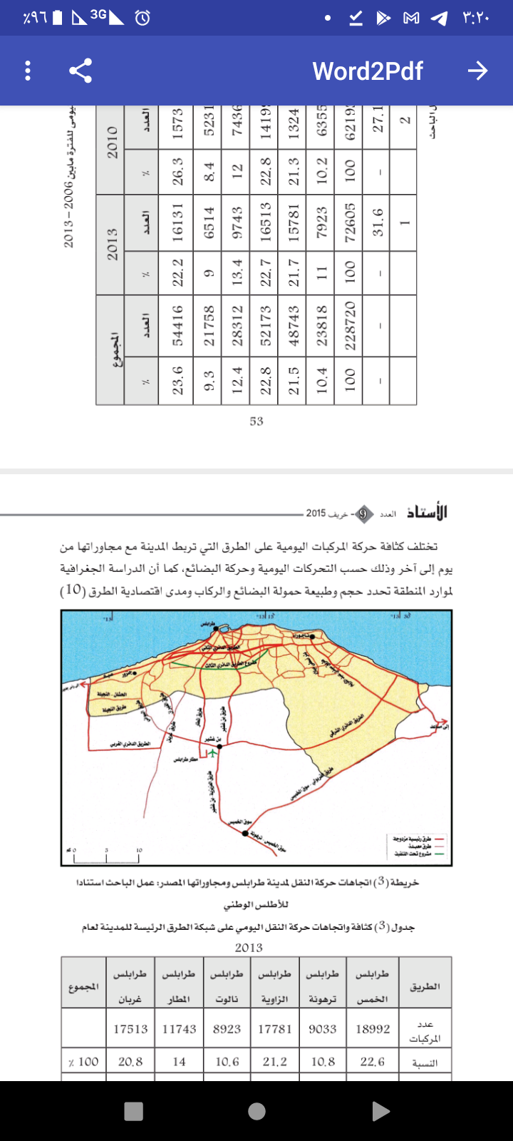
Figur5:Tripoli City roads
In India, in the Mobi region, researchers Nagendra R. Village and Sunder L. Dingra developed an intelligent road maintenance and rehabilitation system based on GIS and GPS systems. The importance of road maintenance and rehabilitation stems from the importance of preserving the road and sidewalks in order to reach a high level of service and make optimal use of the limited budgets for maintenance and rehabilitation. Where an easy system for maintenance and rehabilitation of roads (M&R) was developed through (GIS) systems in order to find the effective cost and strategies for maintaining the road networks in case they are usable. The spatial pavement and road condition data and the road network data were collected using the GPS, and separated and arranged spatially on the GIS platform. The use of M&R tools developed in TransCAD’s GIS units. The research aims to develop an M&R system (road maintenance and rehabilitation) that enables timely decision-making support and decision-making, allocating budgets and allowing maintenance engineers to carry out daily or periodic maintenance work, using a priority index approach, appropriate rehabilitation strategies, budget requirements related to governance, and the impact of Budget available on vehicle operating cost, roughness, and additional requirements based on size and capacity. It was concluded in this study that strengthening the monitoring system, which was developed in this study, is effective in daily road maintenance and is useful in decision-making and planning process that can be shared by various planning and maintenance authorities, road scheduling and monitoring processes, and then using the approach. A priority indicator for making a decision on a maintenance strategy is experimental in nature as figure 6. Further studies can be performed using current mechanical methods of choosing maintenance therapy rather than the experimental approach. [7]
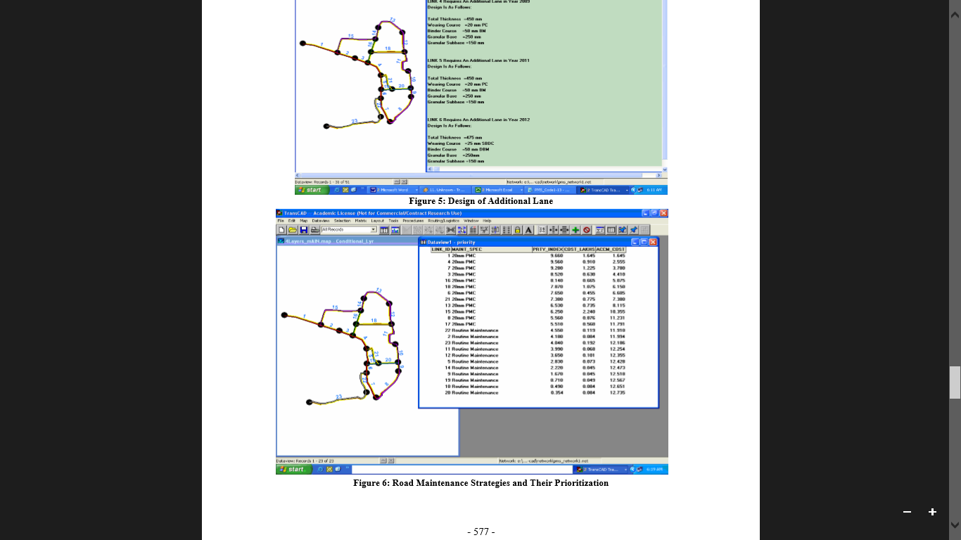
Figur6:Road maintenance strategies and their prioritization
In Turkey, researchers such as Population, Pedroglio Yildirim, were able to determine the forest path through multilingual spatial decision-making methods based on geographical information systems, from the development of an intelligent system for road maintenance and rehabilitation based on GIS and GPS systems. Forest roads are one of the most important infrastructure for forest operations, which are also renewable natural resources. Forestry operations include forest path design and slope stabilization, harvesting systems analysis for economic efficiency and site protection, and crop planning and scheduling as well as transportation systems. Therefore it was necessary to establish ways to achieve the objectives in order to plan forest operations within the framework of the concept of sustainability. The research problem revolves around that identifying forest road routes is a complex process in which a number of variables must be analyzed simultaneously, and it is one of the most important practical steps for forest road projects. The research aims to identify the effective factors on forest road routes mainly and to determine the effects of each factor as a weight factor and should be evaluated and analyzed as a whole. Since factors influencing forest road routes are essential and demonstrate management of intense spatial data sets. Fast and accurate results were obtained through the use of decision support systems known as geographic information systems (GIS), where they used a dynamic method to determine the forest path using a decision support system called FOROR (Forest Road). They developed it which is a raster-based system, and is based on GIS techniques. The main factors affecting the forest road pathway and required geographic data layers were identified accordingly, and then classified according to the criteria for this application, Analytic Hierarchy Process (AHP), Weighting (SAW), Fuzzy Overlay, Promethee, and TOPSIS methods were used for multi-criteria spatial decision methods (MCDM). The analyzes were performed using five different methods to determine the forest paths that were compared with each other as well as with the current forest path. Determining a forest path is a complex process since these fields consist of several environmental factors as there are many different aspects of choosing a path . To choose the path, if the model is adopted on the private sector, then only economic factors are a side, and there is another important aspect as well, which are environmental factors, which academics and environmental care groups focus on. In this model, various aspects of the above were considered and an ideal model (MCDM) was created for saving the environment and economy. The use of MCDM based on geographic information systems showed that it provides an optimal solution for forest road pathway identification as figure7. [8]
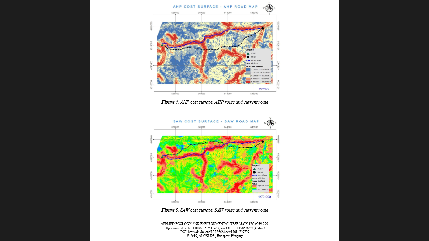
Figure7:MCDM to showed optimal solution for select forest road
[3] Geographic information systems in infrastructure:
In Palestine, researchers Ibrahim Waladali and Muhammad Abu Al-Rub studied the development of a geographic information system to manage water supply networks in the Palestinian areas, taking the city of Halhul as a case study. The research problem is crystallized in: The cities, villages and camps of the West Bank and Gaza Strip suffer from a chronic shortage in the quantities of supplied water that prevent economic growth and cause great damage to the environment and health. This major shortage in the quantities of water supplied to the Palestinians is mainly due to the policy of the Israeli Water Company (Mekorot), which limits the amount of water that is pumped into Palestinian communities from underground water tanks. The other reason is the rapid growth of the population, the insufficiency of water distribution networks, the high leakage rate in drinking water networks (as the rate of wastage reaches about 50%), and the increase in activities related to agriculture that require large quantities of water. In light of this acute shortage of water quantities, many municipalities and local councils, as temporary solutions, divide the city or village into several regions and then distribute the water on a rotating basis. The study main objectives are to explore ways through which GIS software can be used as an effective tool to assist engineers in the field of designing and managing water distribution networks that are not connected to water continuously, and other goals are the possibility of using GIS software as an integrated tool in the processing of comprehensive spatial data To design and manage water distribution systems in which water does not flow at all The study found the need to use geographic information systems applications in designing and managing water distribution networks, because the rate of increase in population in developing countries and the severe shortage of water quantities forced engineers to rethink more effective ways to manage the assets and assets of water networks, as this The system works to provide a complete coverage of the life of the entire water network, starting with planning until the switch, and is useful at the same time for future forecasts and projections of the networks. It also gives the opportunity to managers and engineers to make the necessary adjustments and expansions in a way that ensures high efficiency in the management process of water networks.The use of geographic information systems in managing the assets and assets of water distribution networks gives more accurate results if linked to other programs related to the design and management of water distribution systems. The study recommended that governments in developing countries begin to benefit from the benefits provided by GIS applications in this field due to the effective management of water distribution networks as figure8.[9]
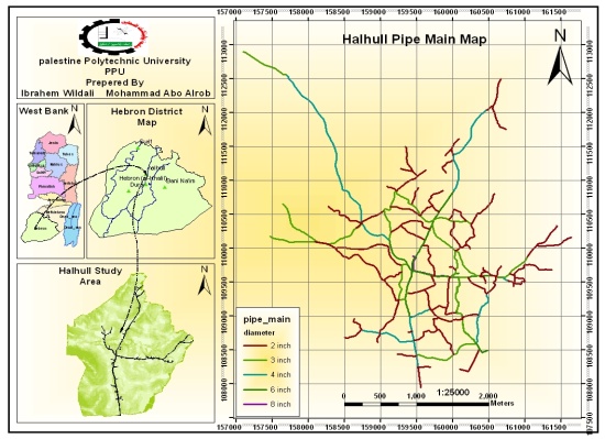
Figure8:Halhul City Water Network Solutions
In Sudan, the researcher Mawhib Kamal studied the effectiveness of using geographic information systems to re-plan and distribute communication networks. And I took a case study on Zain Telecom, The importance of the research stems from the necessity to provide quick and accurate information on the density of the population, their living standards and their future growth, which enables telecommunications companies to know the quantity and capacity of the buildings and the number of towers required to cover the area with a communication network. The problem of the study is summarized in the distribution of buildings and communication towers through the GIS system, as the reasons for choosing this problem were: the lack of systems that enable accurate and timely display of the required information, the difficulty of inquiring about the required information, as well as some reports lack accuracy and synchronization and the difficulty of conducting adjustment operations And correction in the presented data .The research aims to facilitate the presentation of data to the beneficiaries in a way that enables them to benefit greatly from it, and the possibility of increasing the efficiency and synchronization of reports. And also facilitate the process of making decisions in a timely manner, by providing accurate, fast and reliable information. Where the study embarked on studying the company’s distribution system for the cell phone towers network in Bahri city, and then designing a system for distributing the towers through (GIS) . Where a simulation system was made for the current distribution of the towers through the Mat lab program, through which the factors affecting the signal and the weakness of the network (coverage) were calculated, and the (GIS) program and its tools were used to obtain a map showing the distribution of the current telephone network in the region. Then, after that, designing tools to measure signal levels, then analyzing them in terms of the location of the towers and comparing them with the population density and taking into account the dimensions approved by the World Health Organization. Then, a new model for the distribution of the towers was reached, taking into account the optimal distribution of the towers to obtain complete coverage and a lower cost as figure9. [10]
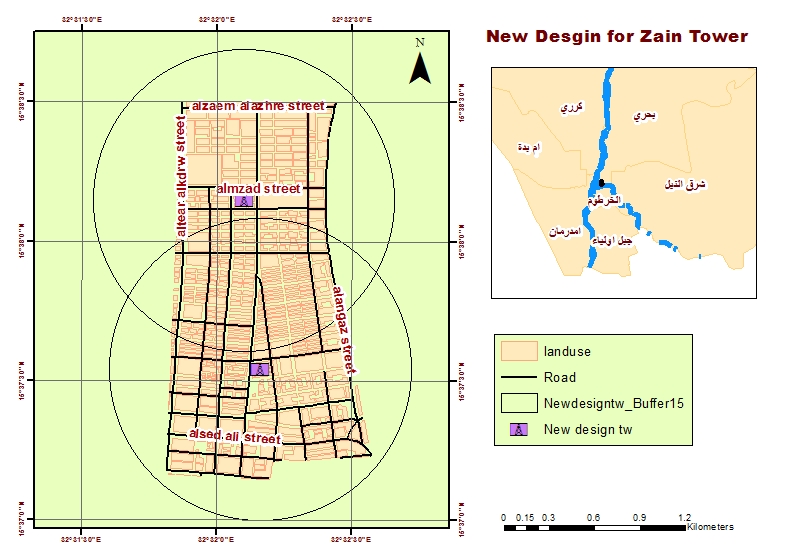
figure9: new design for zain tower
In Jordan in the governorate of Irbid, the researcher Taghreed Khadhat studied the uses of geographical information systems as an important tool in planning and managing electrical systems, maintaining them, raising the efficiency of their uses, and studying the effects of social and economic activities that depend mainly on electric current. Whereas, the basic research problem is spatial analysis when expanding electrical networks and their extension, and the inability to find descriptive, digital, or graphic data to analyze and process the elements that exist within the specified temporal and spatial framework of the area, land uses, public services, infrastructure ….. etc of the important information that affects Electricity networks and their extension. The research aims to use geographic information systems to benefit from them in building maps that provide accurate and up-to-date information on land use and population distribution, as well as identifying the best new locations for electrical poles and transformers and distributing existing services, in order to ensure that costs and efforts are reduced to provide the best to subscribers, follow up on complaints tables, and analyze and extract completion reports and continuous monitoring of the performance of the networks. The ability to manage and operate electrical networks and maintenance work on them, and to show any effect, change or malfunction that occurs on the networks, or when a breakdown occurs in an electrical transformer, or to know the feeding area of each transformer, through the direct and live link to the databases. Which had a great impact on good behavior in crises and reduced implementation time and appropriate decision-making, as well as geographical information systems provided the possibility of tracking vehicles vehicle tracking systems, which contributed to the accurate and detailed follow-up of all vehicles belonging to the company, as it allows obtaining different information about what happened during the vehicle’s trip from The starting hour to the return hour and reviewing the full flight path at the end of the day or during a specified period, in addition to the speed at which the vehicle traveled, the total distance traveled, knowing the location at any moment and many more detailed information that is useful in tracking the movement of field teams and vehicles of the company as figure10. The study concluded that documenting and presenting data on network components and their efficiency through the use of geographic information systems greatly determines the level of utilization from them, which significantly affects the results, and provides the process of network analysis and various means to study any network, and express this in a digital form. In decision-making as it is easy to obtain information through it, make analyzes and models, study all alternatives and know the impact of any decision before implementing it. as figure 10. [ [11
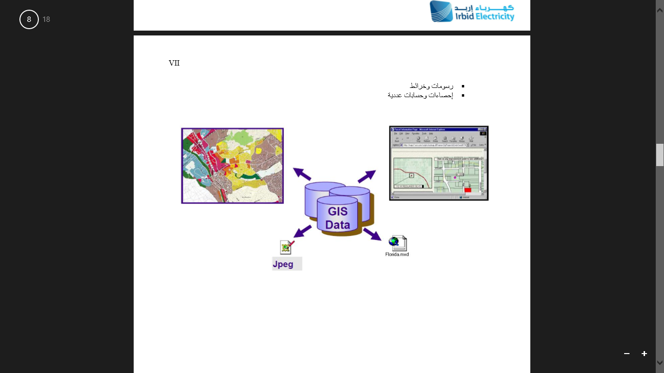
Figure10: usage GIS in planning and maintaining electrical systems
In Sudan, researchers Ahmed, Seddik, Anas and Abdel Rahim studied the use of geographic information systems in the analysis and design of a sewage network for the Rahmaniyah scheme north of Khartoum, Bahri, Halfaya al-Muluk. The importance of research in the field of benefiting from the applications of geographic information systems techniques in designing sewage networks, and studying the current situation in the planning environment for the design of sewage networks is evident. The research problem revolves around the low level of awareness and interest in the information infrastructure in the design of sanitation networks, with the absence of modern planning thinking and the continuation of developing traditional plans that are not scientifically and accurately studied. The research aims to use geographic information systems in designing and analyzing sewage networks for the planner, highlighting its role in preparing a sewage network, and designing a geographic information system that helps in decision-making in the disposal of sewage networks, and managing them in an optimal way to avoid high levels of pollution of treated water and to ensure more quality of services provided. To the citizens, and to accelerate access to information for the benefit of all those involved in the network, for good programming and planning for the development of the sewage network . The study reached results expected from GIS systems in analytical power, the most prominent of which is its ability to simulate three dimensions, create an updateable database, maintain paper and computer equipment, and create a geographical database for all water, sewage and electricity networks in order to ensure that these networks do not interfere in the future and to provide a database that Refer to it if this infrastructure is to be modernized and developed. And facilitate access to geographical data to identify the type of problems that may arise on the infrastructure networks and how geographic information systems facilitate access to the site of the problem and thus address it as quickly as possible and at the lowest cost as figure11. [12]
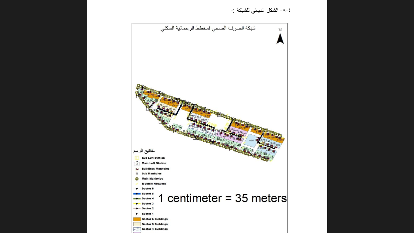
Figure:11 The drainage network of the Rahmaniya scheme
In India, researchers Sangeetha, Puruchuthaman and Suresh Babu presented a paper on estimating the cell phone signal intensity and determining the most suitable place to set up the antenna using geographic information systems and remote sensing (RS and GIS). Development of GIS- and GPS-Based Intelligent Network-Level Road Maintenance and Rehabilitation Site. The researchers aim to study the frequency intensity and determine the best place to set up the antenna. The current survey is designed to determine the signal strength between the base stations and take the predicted signal strength through the integration of the NDVI methodology to measure the effects of the surrounding terrain factors (such as trees, trunks, leaves and branches), their density and height relative to antenna heights as figure12.The researchers concluded that it is possible through remote sensing (RS) and prediction of the signal strength directed by GIS, as this greatly improves the quality of frequency strength prediction compared to the theoretical free space model that was previously used and which is affected by the terrain surrounding the region, and the analysis of the field of view GIS has great potential to help plan future network extensions. [13]
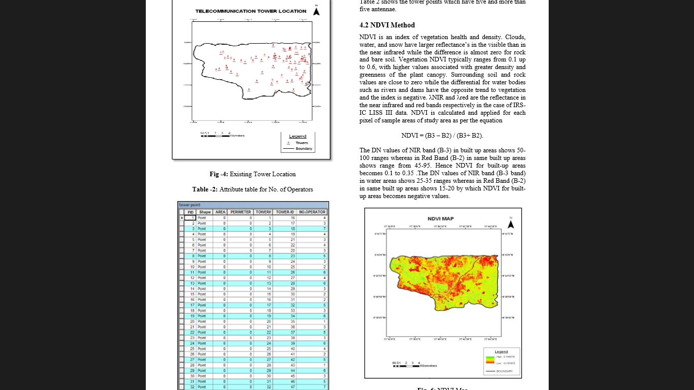
Figure 12: The NDVI methodology
[4] Geographic information systems in services:
In Egypt, the researcher Yasmine Kamel Salem studied the applications of geographic information systems (GIS) in tourism planning and the current situation in the uses of geographic information systems (GIS) in the planning environment of the tourism field. The research problem is represented in the low level of awareness and interest in the informational infrastructure of geographic information systems (GIS) data in the tourism field, with the absence of modern planning thinking and the continuation of developing traditional plans that are not scientifically and accurately studied, which does not take into account the environmental dimensions of the nature of the places to be counted and developed. What shows weakness and shortcomings in the tourism plans and their incompatibility with the actual reality. The research aims to shed light on geographic information systems (GIS) and highlight their role in preparing tourism development plans, identify the benefits that accrue from geographic information systems (GIS) in tourism planning, and inventory and evaluate the uses of geographic information systems (GIS) in the Egyptian tourism sector as figure(). And the preparation of a proposed geographical database (Database) that includes all the tourist sites of the city of Alexandria. The research has reached answers to the question: Does the ministry or institute apply geographic information systems in tourism planning and in the tourism field in general?, The answers collected from officials were known to them, but it is not integrated into the nature of their work when planning a tourist site, as visual images are relied upon only by GPS remote sensing, and the results also showed that many workers do not know the nature of GIS technology, its benefits and uses in Tourist planning. Then the research presented a summary of the use of geographic information systems in tourism development in terms of its potential to build a descriptive and spatial tourism database, facilitate the process of obtaining data easily and conveniently in order to exchange and preserve tourism data and information, and its ability to analyze and show the available and neglected capabilities and all issues related to the development Tourist areas, the level of tourism services and the volume of revenues that accrue to the tourist destination, And the great benefit that is its contribution to the right decision-making process for planners and investors in the tourism development process, and the issuance of tourism maps for cities that have the most prominent sites that tourists flock to, represented in maps of archaeological and heritage sites, museums, parks, parks, entertainment cities, popular markets, malls, commercial complexes, exhibition centers and celebrations. And hotels of all kinds, places of transport stations, car rental, hospitals and police stations as figure13.[14]
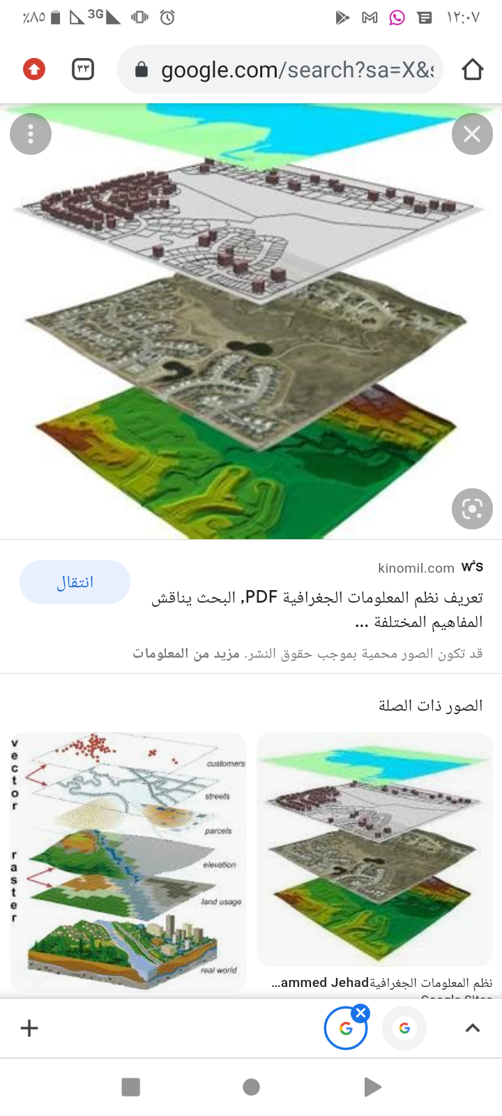
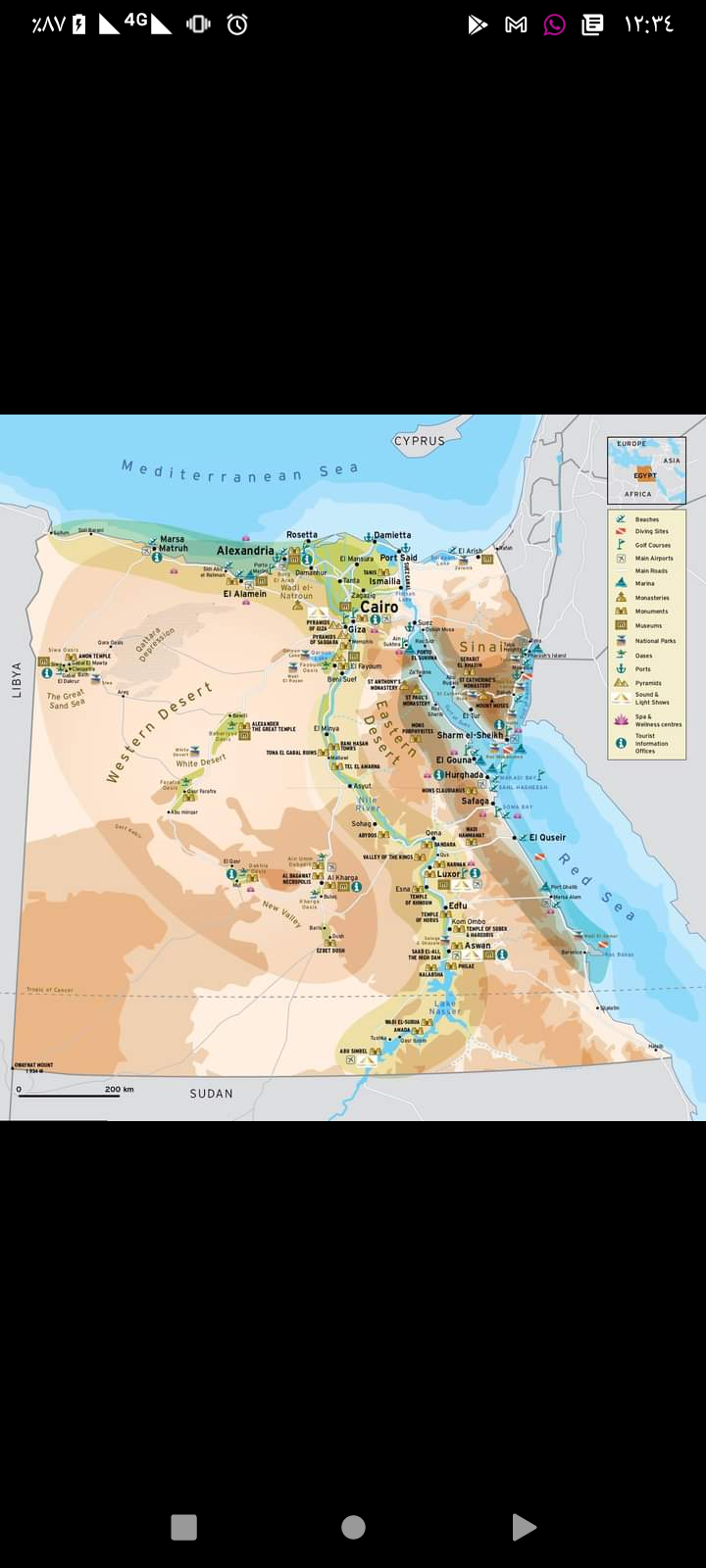
Figure13 : GISArchaeological Sites in Egypt
And in the People’s Democratic Republic of Algeria, Dr. Abu Al-Qasim Hamdy studied the use of geographic information systems and their role in managing health disasters, by focusing on the nature of those systems of a special nature and explaining their role in decision-making in the field of health disaster management. The importance of the study stems from the following: the importance of public health in itself, considering its protection and promotion among the priorities of ministries and international organizations, and the great role played by the information system in general, and the automated geographic information system in particular; The geographic information system provides data and information of a geo-logistical nature that helps avoid disasters and health crises. The research aims to demonstrate the importance and role of the geographic information system in promoting health through effective health disaster management. Demystifying this type of information system, which has not received sufficient attention yet; And trying to uncover the benefits that this system performs and achieves, as some believe that its role is exclusive only on the geographical and logistical side, While we find that it has a great role even in the areas of health; He linked the benefit of this system to the field of public health . The research reached a set of effects and benefits of this system in two parts: before and after the disaster. A geographic information system has been adopted to provide geographic information. It helps uncover various natural and non-natural threats to health and humans; It was the link between it and disaster management in which we focused on health disasters as figure14 .[15]
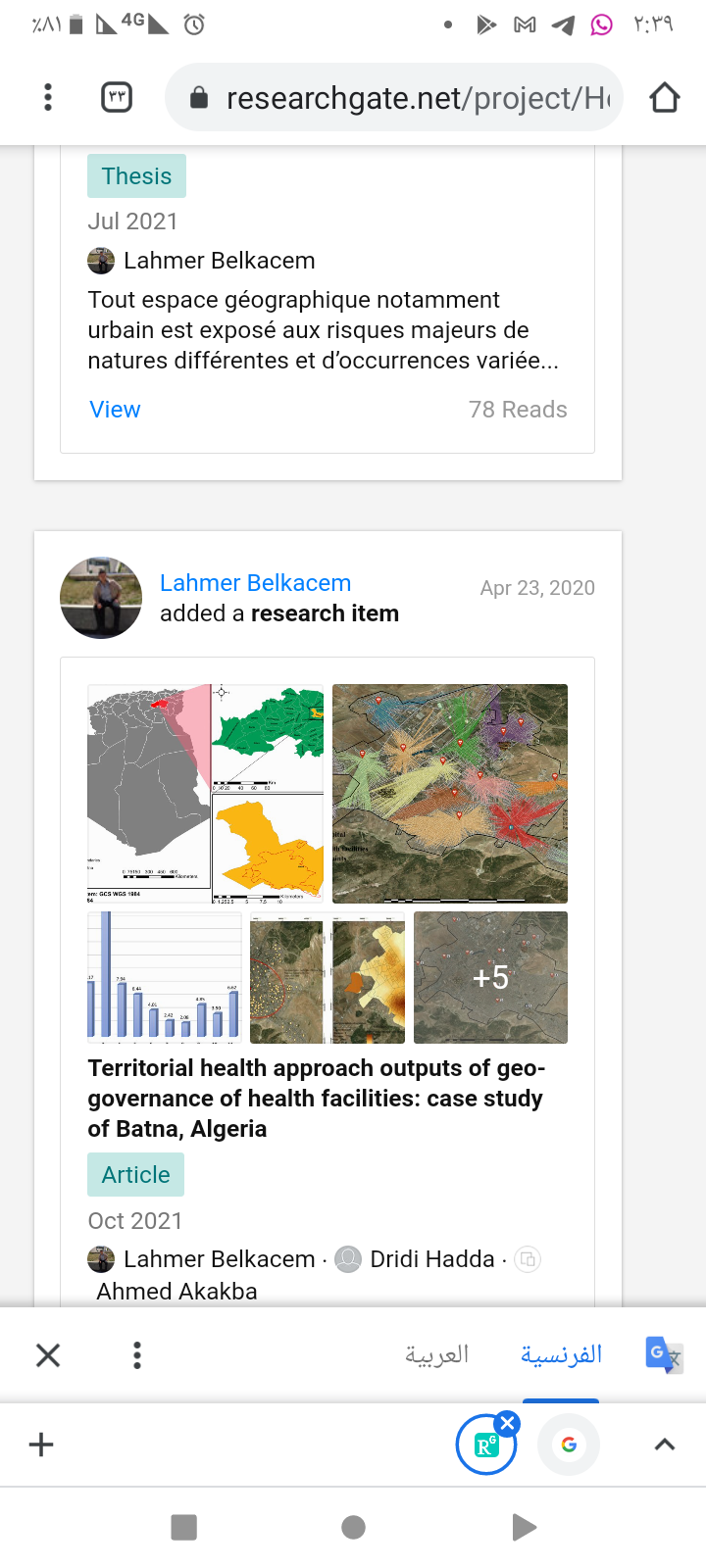
Figure14 : GIS managing health disasters
In Iraq, Dr. Suqi Al-Ghazi presented a paper on the Infrastructure Project for the Iraqi Geographic . The problem of the study is summarized in the fact that the process of making sound decisions in the usual business, planning for projects and others requires the availability of accurate and up-to-date information, and since the geographical data used by public institutions are almost similar to a large extent, as is the case in most countries that suffer from the absence of an integrated structure that organizes use The one who subscribes to this data between the institutions and assumes responsibility for producing, updating and maintaining data, The paper aims to study the basics of the Iraqi geographic information infrastructure (ISDI), the methods of upgrading it, and the study of global experiences in this field, which is relied upon to provide a general electronic service, and to regulate the joint use of geographical data among the various sectors of the state, and to determine the responsibilities towards this data in terms of its production, updating and maintenance. This is to ensure that information is provided permanently and under all circumstances through a unified network linking all state institutions with each other. The study concluded: that geographical information systems (GIS) are considered a digital mapping system that depends on the capabilities of the computer in providing the service of collecting geographical data and statistical and descriptive data and determining how to access, retrieve, analyze and display methods. Geographic information systems have evolved to become an infrastructure to collect and provide all types of geographical data to support decision-making, especially those decisions related to multiple sectors at all levels, and that the Iraqi Geographical Data Infrastructure (ISDI) will support the process of coordinating and disseminating basic geographic information among all sectors of the state, government institutions and major organizations and The same stakeholders in Iraqi society as figure15. [16]
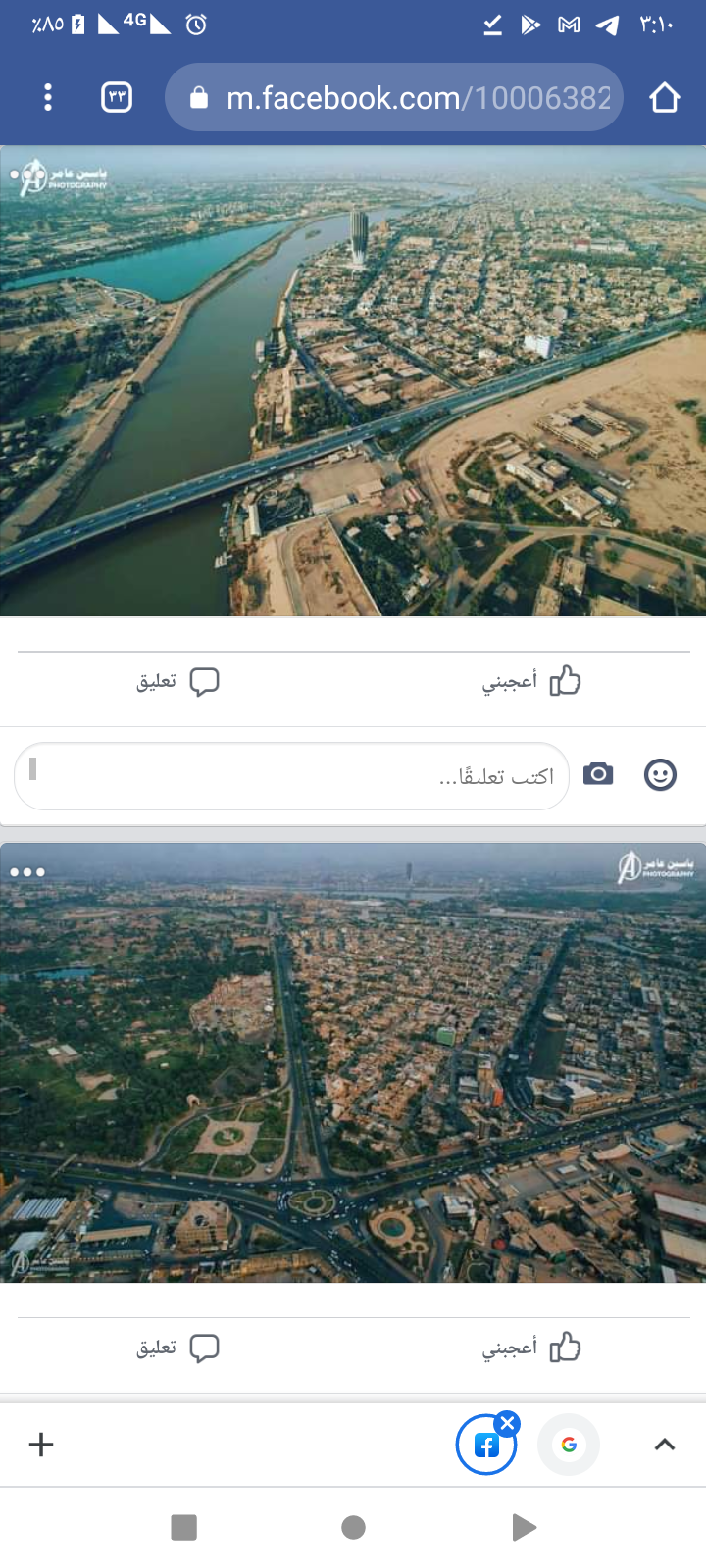
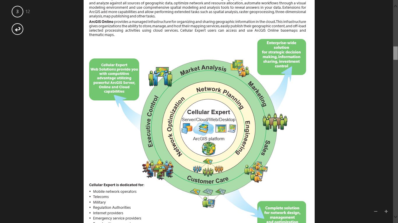
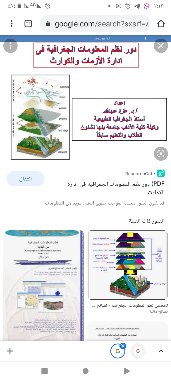
Figure15: Iraqi Geographical Data Infrastructure (ISDI)
The introduction of the paper benefited from the previous studies and other geographic information system research and studies in the management services infrastructure and transportation. It was targeted by the Sudan transportation department . It has analyzed the current system of transportation in Khartoum State. The Department of Transportation & petroleum is responsible for transport and petroleum distribution of the Ministry of Infrastructure and transportation of Khartoum state. by providing safe and modern transportation and distinctive operating systems for passenger transport. Thus, the future development and optimal exploitation of the transportation system in accordance with the directions of the structural plan for transport and traffic in Khartoum state, and the development of the infrastructure of the transport system and the optimal exploitation of it (streets and private and public vehicles). also providing storage supplies for petroleum materials efficiently and effectively and is responsible for supervising and monitoring their distribution in the state. It is clear to us through the study of the current transportation system : Dual tasks, consequently increased costs, fatigue in planning, poor flow of information, and overlapping and interlocking relationships with other institutions (roads and bridges, traffic ,… Etc.), which is a key partner in the work, and that the work is done in a manual way, the customer wastes his time in the internal procedures to certify his request, whether it is a transport line or a fuel power of attorney or otherwise, as well as the centrality of the work and the resulting negatives in the work and loss of time and distracting the manager from his supervisory and guidance role.
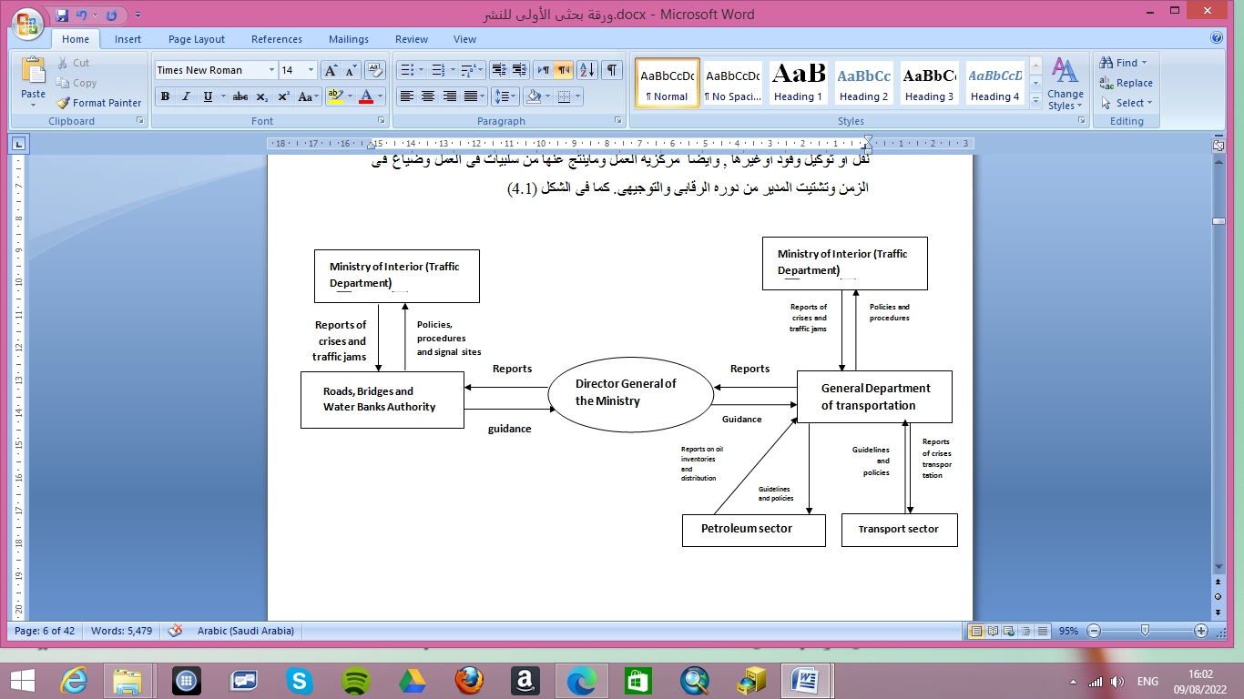
Figure15: current system of transportation in Khartoum
[5] System designed for transportation management (DFD):
A control system was designed for Transportation management to address previous problems in the current system such as: correcting overlapping relations and making them in two horizontal (management and related institutions), and vertical (transport department with its internal departments and the supreme administration of the Ministry). division of relationships has made it easier to flow information and manage crises with immediate and future solutions such as addressing the scarcity of transportation and traffic jams at certain times or throughout the day. also Computing internal work (of the department as sections with each other) and external work (management with its customers in terms of collision ((lines and distribution stations)), and management with the department of the ministry and other relevant authority and institutions) ,through an integrated computer system. The role of the director became oversight and guidance. The system’s reports have also been linked to appear clearly on maps, which are useful in the process of remote control and the availability of accurate and rapid information about the current state of the transport network for crisis and bottleneck management.
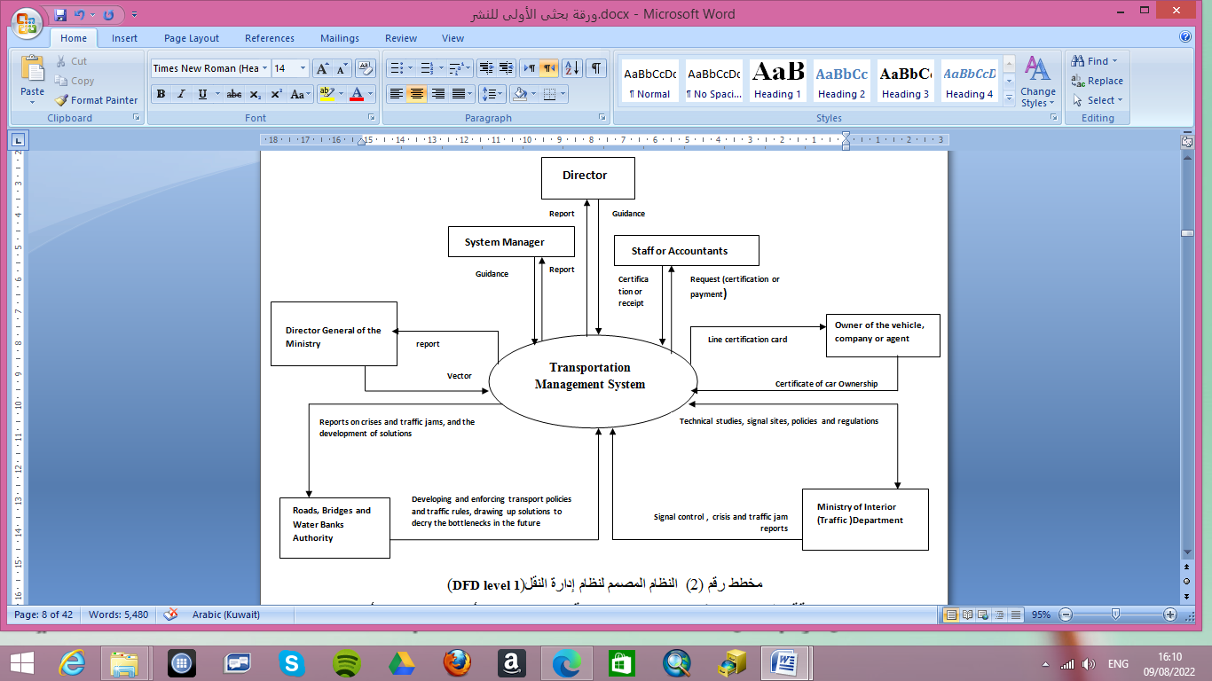
figure2: design of Transportation Management System
[5] Conclusion
The conclusion from the review of a pervious studies scientific papers is that geographical information systems have contributed to the development of several sectors. As geographic information systems are distinct systems that have the ability to visualize the services (phenomena) and link them to their actual location on nature in maps, as well as provide a vast amount of information (databases) through which problems can be analyzed and appropriate solutions found. It also supports decision makers in taking instant decisions and properly planning for the future, whether that is an expansion of service or selection of new sites. In the field of infrastructure, it has contributed to the expansion, management, planning and expansion of water, electricity and sewage networks, as well as communications. In the field of services, it contributed to expanding the base of services and their comprehensiveness by using them in tourism planning and health disaster management and in the infrastructure project for the Iraqi Geographic Information System (ISDI). The author of the scientific paper also benefited from all previous studies in its analysis of the current transportation system in Khartoum state and was able to implement GIS software on it to benefit the senior management in controlling transport systems and their monitoring and the possibility of supporting them by choosing the right solution in a timely manner and benefiting from the available alternatives.
[6]Rfrences:
- Dr. Al-Mutair, Amer bin Nasser. The Reality of Public Transport by Private Buses in Riyadh. Saudi arabia, 2013.
- Daghfal, Hoda. Studied the use of geographic information systems in preparing the traffic and movement plan for the city of Al-Musliah. Algeria, 2015.
- Ford, Alistair C, Stuart L. Barr, Richard J. Dawson and Philip James. Transport accessibility analysis using GIS: assessing Sustainable transport in london. London, 2015.
- Al-Qarni , Abdullah bin Muhammad. The role of geographic information systems in good traffic management in long roads. Saudi Arabia, 2012.
- Brown. Study of an environmental modeling system based on geographic information systems for transport planners. Australia, 2009.
- Ayad Al-Majdoub ,Engineer Hussein. The use of geographic information systems to download road networks Al-Biruni Center for Remote Sensing. Libya, 2010.
- Nagendira, Sunder. Developing an intelligent GIS network and GPS system for maintenance and rehabilitation system. India, 2011.
- Yildirim, Pedroglio, Population. Determination forest road routes via Gis-based spatial multi-criterion decision methods. Turkey 2018.
- Abu al-Rab , Muhammad ,Ibrahim Waladali. Managing intermittent water distribution networks by using geographic information systems for the city of Halhul. Palestine, 2005.
- Kamal, Mawahib. The effectiveness of using geographic information systems in managing telecommunications services. Sudan, 2016.
- Hat, E.Tgred. GIS applications in electrical networks. Jordan, 2012.
- Abd Al-Ilah, Ahmad, Siddiq Muhammad, Anas Ahmad, Abd al-Rahim Muhammad. The use of geographic information systems in the analysis and design of a sewage network for the Rahmaniyah scheme. Sudan, 2014.
- Sangeetha, Puruchuthaman , Suresh Babu. Estimating the cell phone signal density and determining the most suitable location for the antenna using geographic information systems and remote sensing (RS and GIS). India, 2014.
- Salem, Yasmine Kamel. Applications of Geographical Information Systems (GIS) in Planning. Egypt, 2012.
- Hamdi , Dr.Abu al-Qasim. The use of geographic information systems and their role in managing health disasters. Algeria,2013.
- Al-Ghazi, Subhi. Benefits of using geographic information systems to upgrade work and create infrastructure. Iraq, 2012.
- Okasha , Abdullah Zeian. Lectures Notes “ Kuwait University Faculty of Social Sciences Department of Geography. 2009-2010.
- Al-Shammar , Ahmed Saleh. Geographic information system. First edition, 2007.
- Zain , Muhammad Adam. Research writing methodology. Omdurman Islamic University. Sudan, 2005.
