Mawahib kamal alhaj 1, Ashraf Gasim Elsid Abdalla 2
1Postgraduates school, Al neleen University, Khartoum, Sudan
Kmawahib888@gmail.com
2School of electronic, College of Engineering, Sudan University of Science and Technology
agea33@yahoo.com; drashraf@sustech.net, www.sust.edu
HNSJ, 2022, 3(11); https://doi.org/10.53796/hnsj3117
Published at 01/11/2022 Accepted at 05/10/2022
Abstract
This paper presents the transportation system in Khartoum state in Sudan. Transportation systems in Khartoum state, managed by two separated bodies within the Ministry of Transport & Infrastructure. those are (road bridges authority and transportation department). this led to duplication of planning and overstrain administrative and large financial cost . The data gather from the Transportation Department of the Ministry of Infrastructure and transportation . Then an integration scenario for the management is proposed and a monitoring tool was implemented using Geographical information system. GIS data modeling has been proposed to create by languages php connected by free geo database , The results of the simulation show The administration has been able to solve the problem of transportation crises and traffic jams currently and in the future.
Key Words: GIS, Khartoum Transport system ,monitoring , PHP, road, traffic, management
Transport is the ability to move from one place to another using one of the standard means of transport Transport systems operate in Khartoum state through the Ministry of transport & Infrastructure, where they consist of authority and departments that work separately ,and their relationship with other Ministry(Traffic Department, Ministry of Energy.. etc.)is also separated. All above leads to lack of integration in transport systems and therefore duplication of planning, administrative and financial difficulty in resolving crises. GIS helps to establish control and manage the transportation network effectively that provides solutions to the challenges transportation network for the time being and in the future.
[2] Previous studys :
In Saudi Arabia, researcher Abdullah bin Mohammed al-Qarni studied the uses of GIS in good traffic management on long roads. The problem is to find a network of main (long) paved roads to connect the main areas of the Kingdom and improve traffic management with security and safety. The research aims to connect the main areas to a network of asphalt roads, thereby developing this network and developing the level of services on it, providing safety means, and activating GIS in the road and highway sectors. The research has reached the great role provided by GIS and its support systems to solve the problems of traffic management in long roads, it is one of the most important decision support systems in the world that cannot be dispensed with in the field of city planning and infrastructure. [1]
In the Algerian People’s Democratic Republic, researcher Huda Dahfl studied the use of GIS in preparing the movement plan and passing through the city of Al-Masla. The problem of research is reflected in the challenges facing Algerian cities in the field of service management, transportation, reliance on daily movement schemes, and linking this data with spatial features. The study aims to highlight the importance of applying GIS in traffic planning by creating a database of various elements of the city’s traffic and traffic plan and linking these rules with real features on the map. It was found that the greatest benefit of this is easy access and mobility within the city, alleviating traffic problems in the city center and keeping pace with technological development.[2]
In the United Kingdom of London, researchers Stuart L. Barr, Richardg.Dawson and Philip James studied and analyzed ease of transport using GIS. The research aims to develop a simple tool for rapid analysis of accessibility by different modes of transport, designed to be flexible and have the use of data available to the public (enquiry screens and display maps), and uses the generalized cost tool to measure transport costs across networks including cash components and distance. It is used to display different access patterns for different modes of transport. The following findings were reached: enabling decision makers to rapidly assess the impacts and developments of new infrastructure on accessibility and to explore significant spatial variation in transport and employment costs, highlighting that investment may be required in low-carbon forms of transport.[3]
In Australia, researcher Brown studied the GIS-based environmental modeling system for transport planners, where a GIS-based system and environmental modelling (TRAEMS) were programmed. The research aims to use GIS capabilities to integrate the output of transport planning activity with information on land use to model the environmental impacts of various road traffic scenarios. TRAEMS enables planners to test transport and related environmental impacts at the same time because it is efficient in network planning. The results of the research showed the appropriateness of this type of environmental modeling for planning purposes, as the system was used and used by transport planners to assess the environmental impacts of traffic plans now and in the future .[4]
In Libya-Tripoli, researcher M. Hussein Ayad al-Majdoub studied the use of geographical publicity systems in the analysis and management of road networks. The problem of research is how to manage road networks, which are one of the most important driving areas for urban and economic growth. The research aims to use GIS to develop a digital system and database of road networks and link them to service centers to determine the most appropriate routes between two points in terms of distance and time, where this reduces losses resulting from accidents and fires by choosing the appropriate path to speed of access to reduce material and human losses, identifying the most appropriate sites in the future to establish emergency points such as the distribution of ambulances and civil defense and the establishment of service areas such as the distribution of police stations and hospitals. It was found that the use of GIS is the best solution to eliminate road problems including accidents, congestion and bottlenecks at certain points and at different times through dealing with digital information, which in turn helps in proper proper planning of future projects and acceleration in various services where they can be used in most other sectors of the country .[5]
In The Kingdom of Saudi Arabia, researcher Amer bin Nasser al Mutairi studied the reality of public transport by local buses and took riyadh city as a study area, The research problem revolves around the population increase that has occurred in the main cities of Saudi Arabia, which has led to traffic jams and traffic density on the main roads. The research aims to identify the reality of public transport in Riyadh and the characteristics of public bus transport in terms of the quality of buses used and to identify the opinions of local bus drivers and the opinions of their users. Through his analysis of the data for the main reasons that led to the decline of the public sector’s contribution to the public transport system in the city and not to invest in it, the researcher made his recommendations to the administration to address the shortcomings and overcome obstacles and to make investment.[6]
India in the Moby region, researchers Nagendra R. Village and Sander L. Dingra have developed a smart road maintenance and rehabilitation system (R&M) based on GIS and GPS systems to maintain the road and sidewalks to reach a high level of service. The research aims to develop the M&R system, which supports timely decision-making, budget allocation and allowing maintenance engineers to carry out daily or periodic maintenance work, using priority index approaches and appropriate rehabilitation strategies. It has been concluded that the strengthening of the monitoring system developed in this study is effective in maintaining roads on a daily basis and is useful in decision-making and planning process that can be shared by various planning and maintenance authorities .[7]
In Turkey, researchers such as The Population, Pedroglio and Yildirim have identified the route of forest roads. Forest roads are one of the most important infrastructure facilities for forest operations and include forest road design, slope stability, analysis of harvest systems for economic efficiency and site protection, crop planning and scheduling as well as transport systems. The research problem is that identifying forest road routes is a complex process in which a number of variables must be analyzed simultaneously. The research aims to identify the effective factors on forest road routes primarily and to identify and evaluate the effects of each factor by using a dynamic method of determining the forest route using the decision support system called FOROR (Forest Road Road), a point data-based system based on GIS techniques. It was developed by creating an ideal model (MCDM) to include the measurement of environmental and economic factors. MCDM’s use has shown that it is the perfect solution for identifying forest road routes. [8]
In Palestine, researchers Ibrahim wld Ali and Mohammed Abu Alrub studied the use of the geographical information system in the management of water supply systems in the Palestinian areas. The problem arises: the cities, villages and camps of the West Bank and Gaza Strip suffer from chronic shortages of water supplied, which prevent economic growth and cause significant damage to the environment and health. The study aims to use GIS software to process comprehensive spatial data to help engineers design and manage water distribution systems. The study found that the use of GIS applications provides more effective ways to manage the assets and assets of water systems, and managers and engineers can make the necessary adjustments and expansions and good planning in the future. [9]
In the Jordan in Irbid province, researcher Taghreed Shehtakt studied the uses of GIS as an important tool in the planning, management and maintenance of electrical systems. The research aims to use GIS to benefit from them in building maps that provide accurate and renewed information on land uses, population distribution, identifying the best new sites for electrical columns and transformers, then distributing services including reducing cost and effort, following up complaints, and extracting continuous reports of the performance of electrical networks to benefit from them in maintenance work. When a malfunction occurs in a power adapter, the special feeding area can be identified through the live and direct link to the databases, and the possibility of tracking maintenance vehicles. The researcher concluded that the use of GIS helps in decision-making and facilitates access to information and the work of analyses and models and study all alternatives and find out the impact of any decision before implementing it. [10]
[3] Current system analysis:
The Department of Transportation & petroleum is responsible for transport and petroleum distribution of the Ministry of transport &Infrastructure of Khartoum state, and providing safe modern transportation operating systems for passenger, develop in the future optimal exploitation of the transportation system according with the directions of the structural plan for transport and traffic in Khartoum state. Also providing storage supplies for petroleum materials effectively and is responsible for supervising and monitoring their distribution in the state. It is clear to us through the study of the current transportation system, as in figure 1: duplication of tasks, increased costs, exhaustion in planning, weak information flows, and overlapping relationships with other ministries (roads and bridges, traffic ,… Etc.) . And the work done is manual, and the client wastes his time in the procedures (transport line or a fuel power attorney …ect), also the centrality of the work results in loss of time and distracting of the manager from his supervisory and directional role.
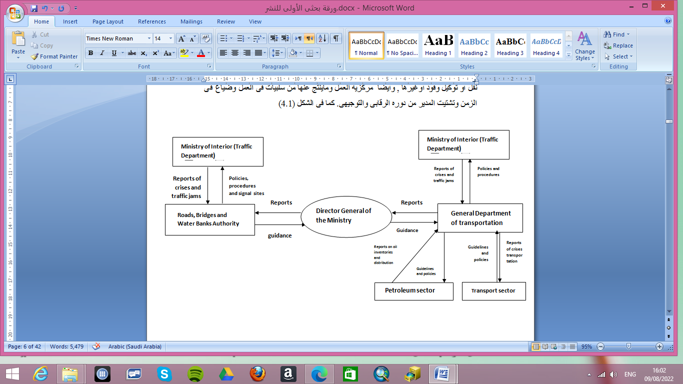
figure1: Current System for Ministry of transport &Infrastructure
[4] designed of transportation management System:
A control system was designed for Transportation management as in figure 2 , to address previous problems in the current system as in figure 2 such as: correcting overlapping relations and making them in two, horizontal(management and related ministry) and vertical (internal transport department and the Ministry administration)and make work with an integrated computer system. division of relationships has made it easier to flow information and manage crises with immediate and future solutions. Then the distribution of tasks and powers to the employees , and the role of the manger became ally supervision and direction , it also enabled the system’s to link the reports appear clearly on maps, which are useful in the process of control and the availability of accurate information about the current state of the transport network for crisis.
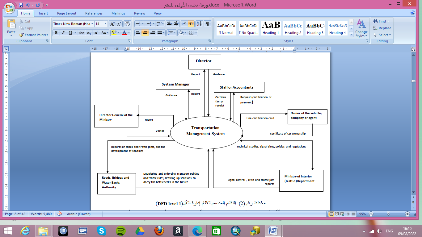
figure2: designed of Transportation Management System
[4.1]The relationship of the transportation management system with the owner of the vehicle as figure3 and distribution agents or the company as figure4:
- Fill out the service application form (line certification, certification of the establishment of a station, investment card).
- Ii. Attach the required documents (certificate of ownership, certificate of guarantee, name of work .. etc.).
- Payment of fees (line fees, construction fees for oil distribution stations, fees for practicing cards).
- Iv. The required documents are confirmed in step 2 (e.g. certificate of ownership through traffic management and so on).
- v. Certification is granted (transport line, station construction)
- Vi. Fuel rations are distributed by the number of distribution stations for the company.
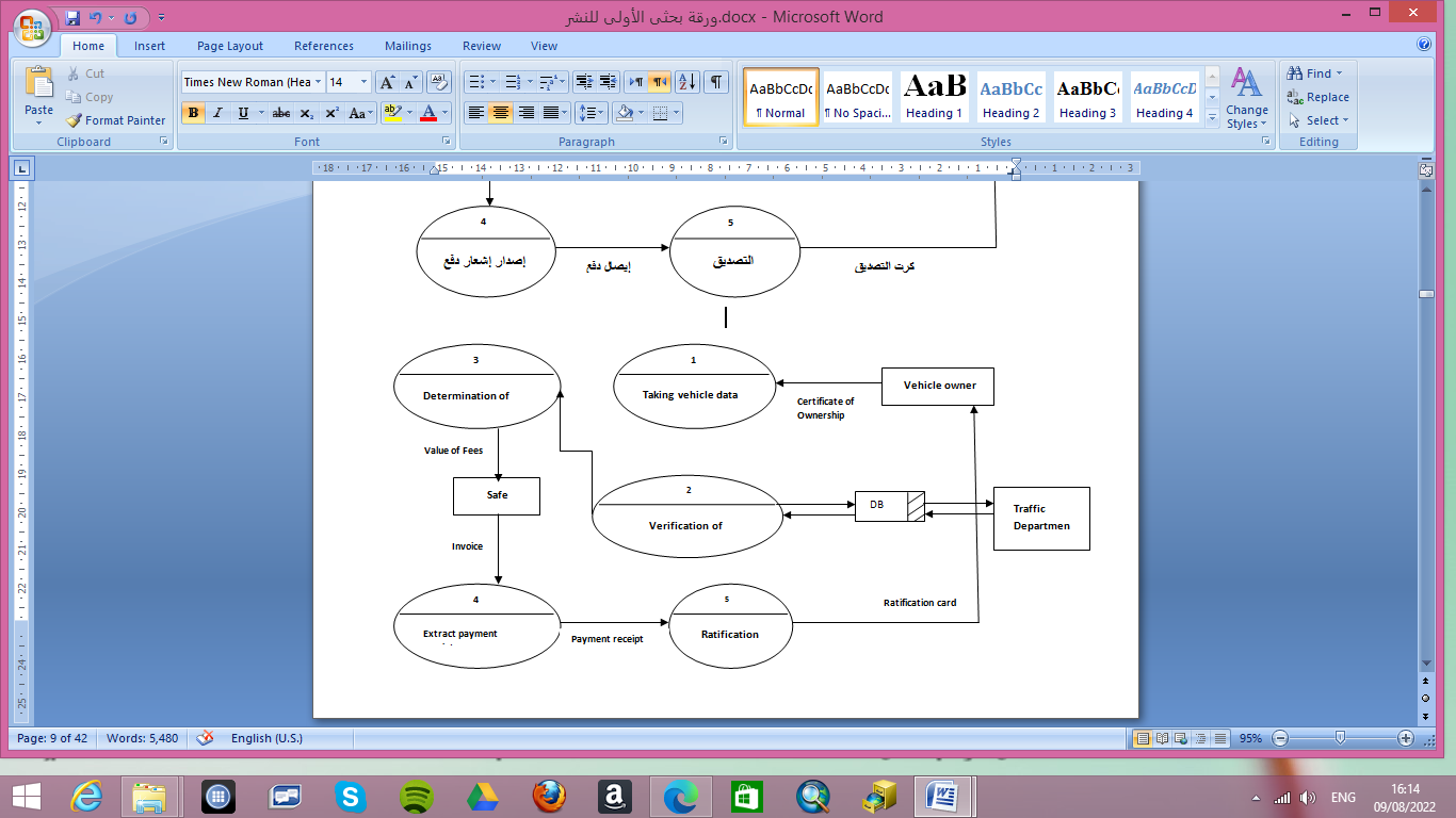
Figure 3: The owner’s relationship with the transportation management system
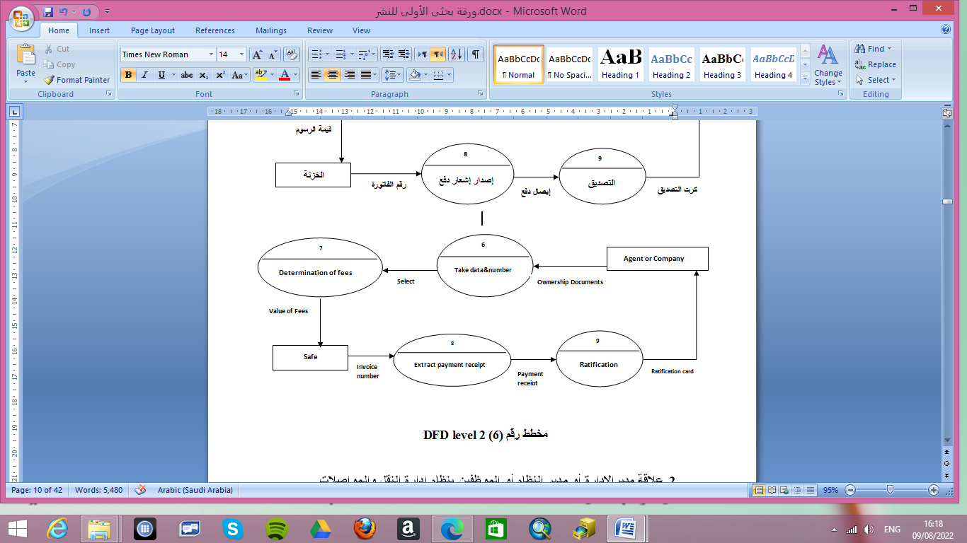
Figure 4: Agents or companies relationship with the transportation management system
[4.2]The relationship of the transportation management system with the Manager as figure5 or system manager as figure6 or employee as figure7:
- The director of the director gives powers to the users of the system and the system manager applies them.
- The director of management and the director of the system are able to extract reports on (state of the system, the workflow of the management departments and related institutions, problems that arise to develop solutions for them and implement them both selfishly and in the future).
- The director of the department (system manager, employees, employees, representatives of relevant institutions) directs their application in the system, according to what has been updated by the Prime Minister.
- Management staff serve customers by reviewing the data entered from them, then generating the financial receipt and issuing the certification card.
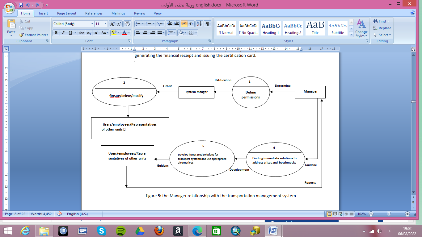 figure5:The manager relationship with the transportation management system
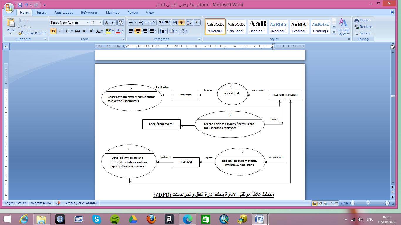
Figure6:the system manager relationship with the transportation management system
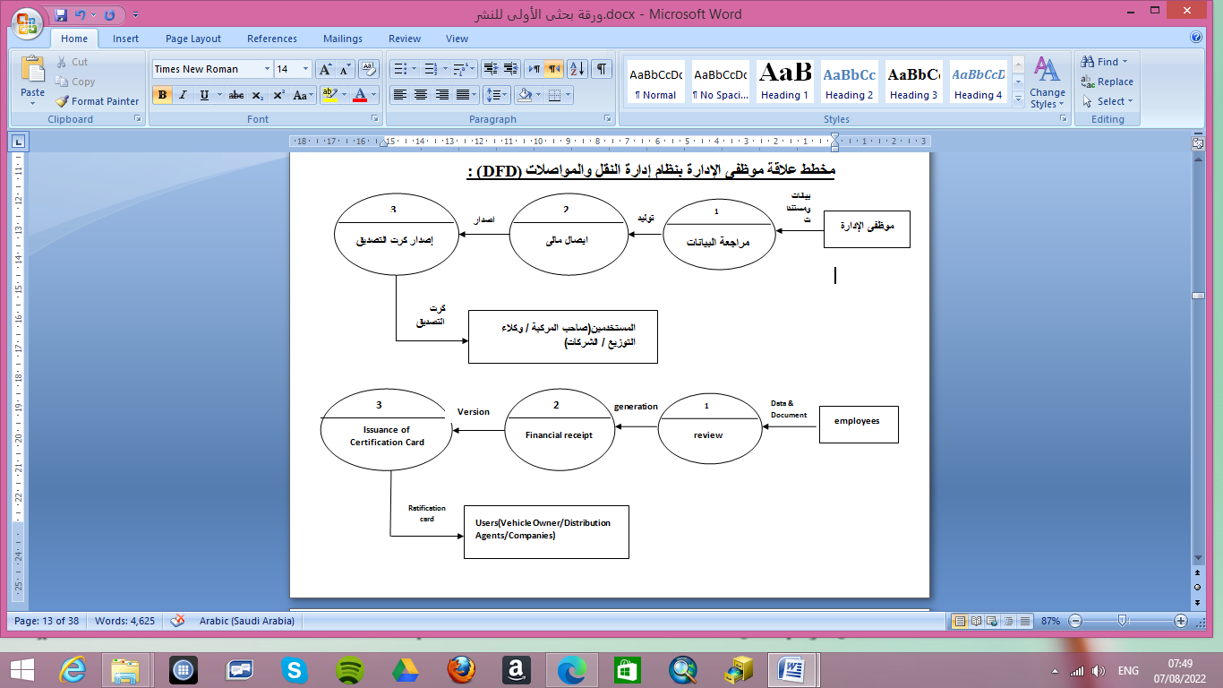 figure7: the employee relationship with the transportation management system
The relationship of the transportation management system with the Director General of the Ministry:
- The Director General provides on time reports on the state and movement of public transportation in the state.
- Provides the Director with reports and maps of current and future transport networks.
- Reports and maps showing the rates and status of fuel in warehouses and stations.
- According to the reports submitted to him and maps, the Director General will issue guidelines and policies for public transport in future plans.
- According to the reports submitted to him and the maps, the Director-General issues directives and policies for distributing fuel quotas to the state and avoiding crises.
- Vii. The system enables the director general of the ministry to make careful monitoring and control of all transportation and fuel in the state.
- The system enables the Director-General to issue guidance and implement policies for system-related units (e.g. Roads and Bridges Authority and Traffic Management).
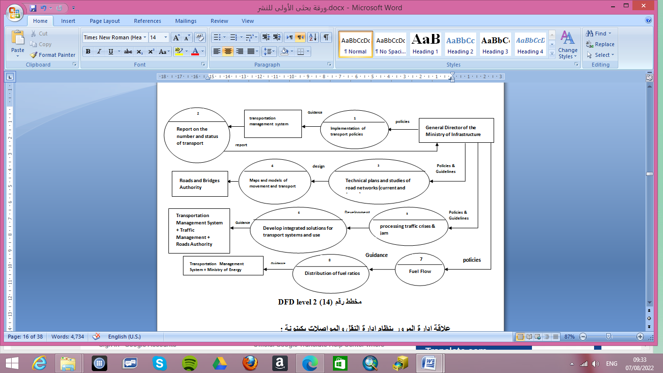 figure8:The Director General of the Ministry relationship with the transportation management system
The relationship of the transportation management system with the Roads and Bridges Authority:
- Design and construction of the Authority for roads and bridges.
- Participates in the implementation of public transport policies in the state.
- Participate in the development of traffic regulations and rules in the use of roads.
- Developing integrated solutions in the future for transport systems and networks by creating or expanding roads. Etc.
- Cooperation with the Department of Transportation in finding any a solutions to traffic jams and the scarcity of transportation and transportation according to reports provided by the Traffic Department.
- Design future solutions to decipher traffic jams and address them radically by creating alternative routes or aircraft elders and taking into account the urban boom and in accordance with the plan for the state of Khartoum.
- The entity of roads and bridges has transgressive relationships with other institutions such as traffic management (feedback information) and benefits the transportation management system as a basis for resolving the transport crises Anya, and the Road and Bridge Authority in the design of future solutions.
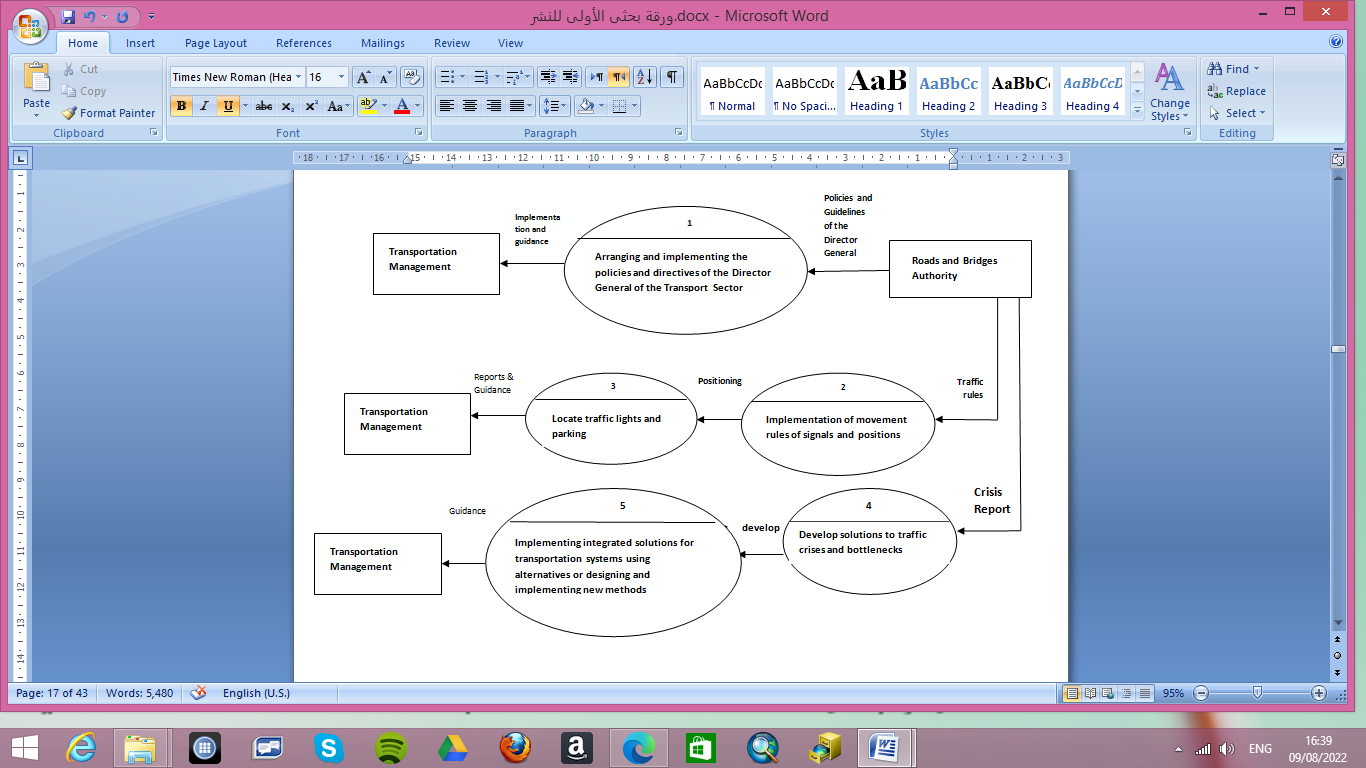
figure9: the Roads and Bridges Authority relationship with the transportation management system
The relationship of the transportation management system with the Traffic Management:
- Check the documents (vehicle, owner of the company).
- Ii. Control and management of traffic lights.
- 3. Crisis reports on transportation accumulate movement and traffic at certain times daily.
- Iv. Provide transportation ports to decipher crises and bottlenecks based on daily traffic reports.
- The work of technical studies of the new lines.
- Vi. Locate positions and determine the starting and end point of each line.
- Locating traffic signs according to technical studies of the lines in cooperation with the Roads and Bridges Authority and traffic management.
- Implementation of transport policies, regulations and guidelines issued annually by the Ministry of Infrastructure.
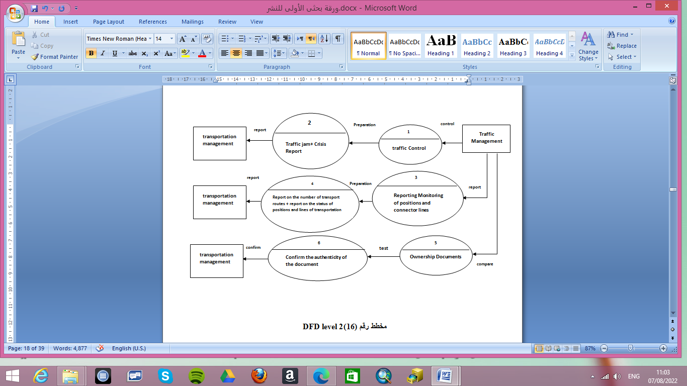
figure10: the Traffic Management relationship with the transportation management system
[5] Results:
[5.1] Modeling construction plans for the transportation management system by UML:
- Owner of the vehicle:
IS the system user of the public (owner of the vehicle), who logs into the system , Then fills out the required data, and then the employee reviews data through the system , and then converts it to traffic for the purpose of verifying the validity of line certification. Then the user pays the fees, after this the employee make the ratification card to him, as figure 11.
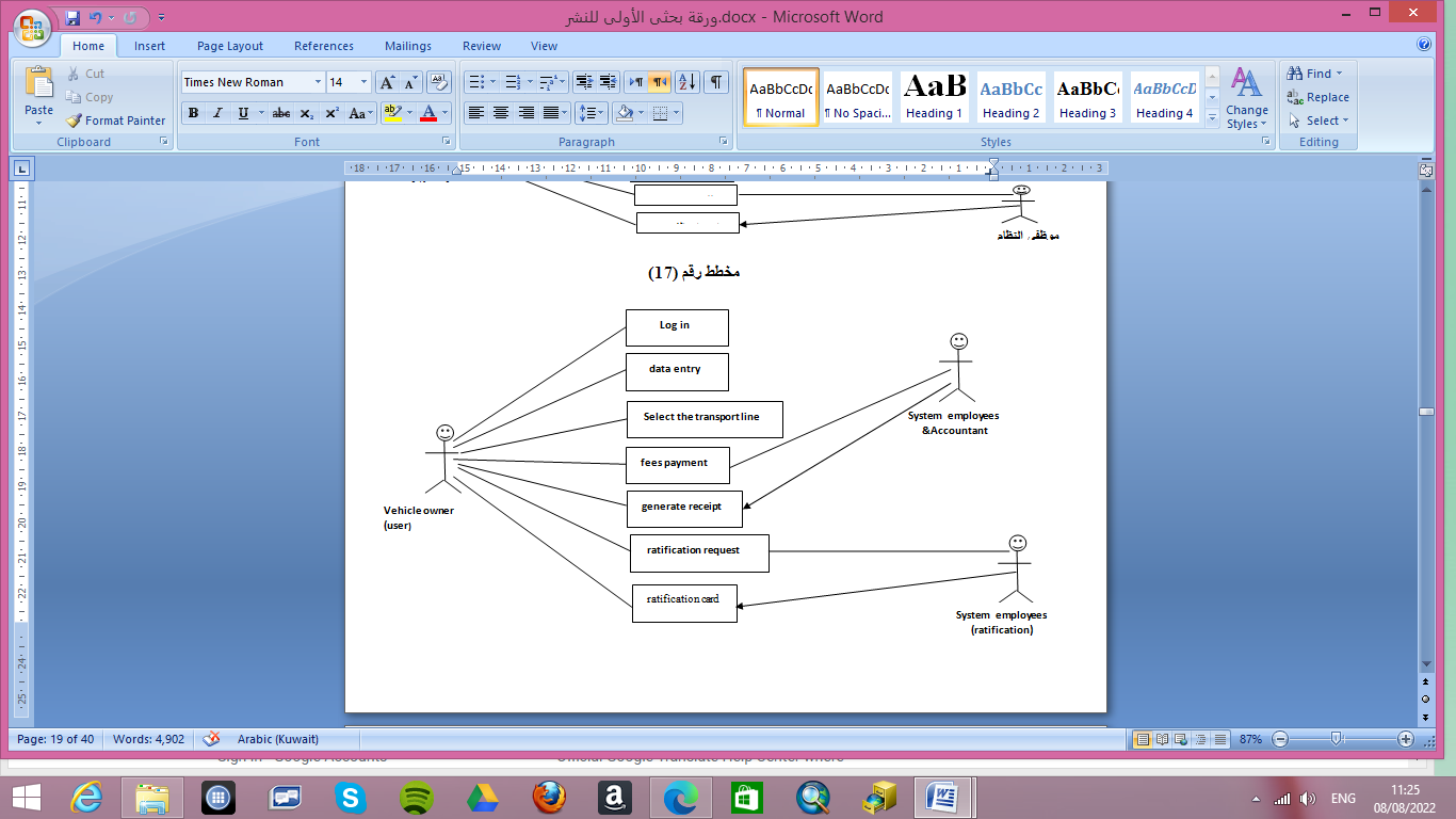
figure11: Figure11: The Owner of the vehicle
- Distribution agents or companies:
IS The system user of the public (agents of fuel distribution companies, agent of taxi or vehicle companies). who logs into the system , and then fills out the required data, then the employee reviews the data through the system, and then the user pays the fees . After this the employee make the ratification card to him.
- System Manager:
He is responsible for the system, its monitoring and control, and (creating/modifying/deleting) users, and then giving permeation as directed the manager of transportation department, as figure12.
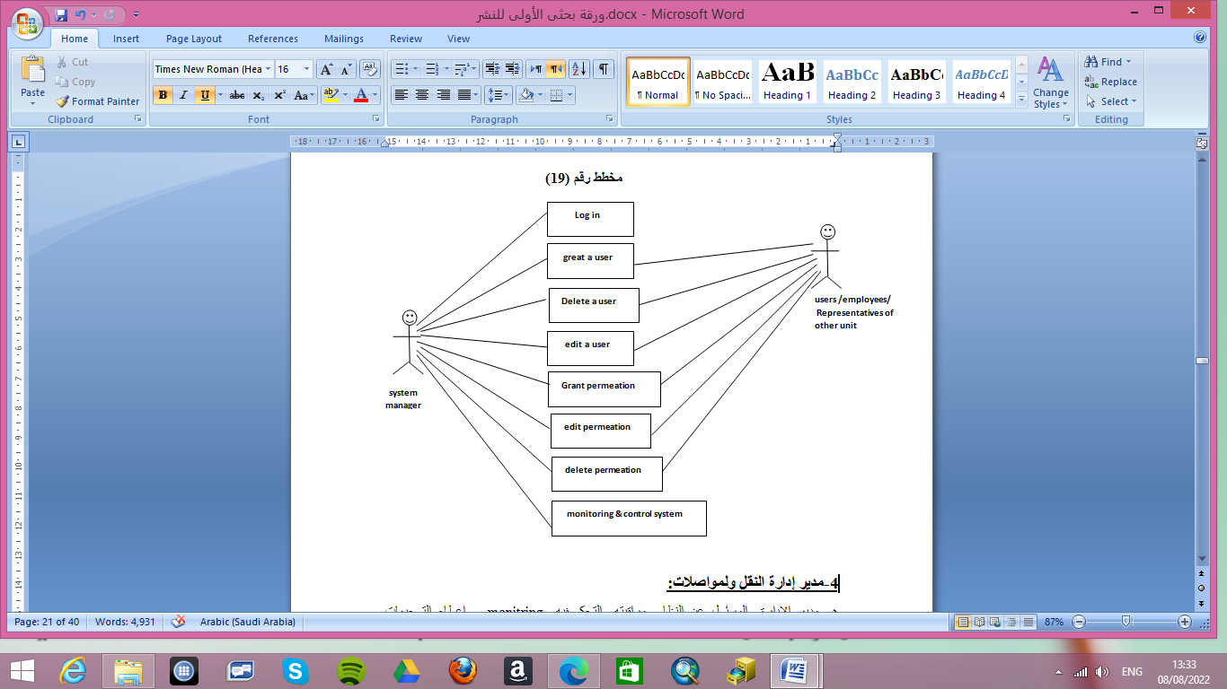
Figure12: The System Manager
- Manager of Transportation Department:
He is the director of the transportation department and responsible for the system and control monitoring, and give the system manager by (creating/modifying/deleting) users and giving them permeation , directing management staff and representatives of other units, and developing technical and future solutions to crisis.
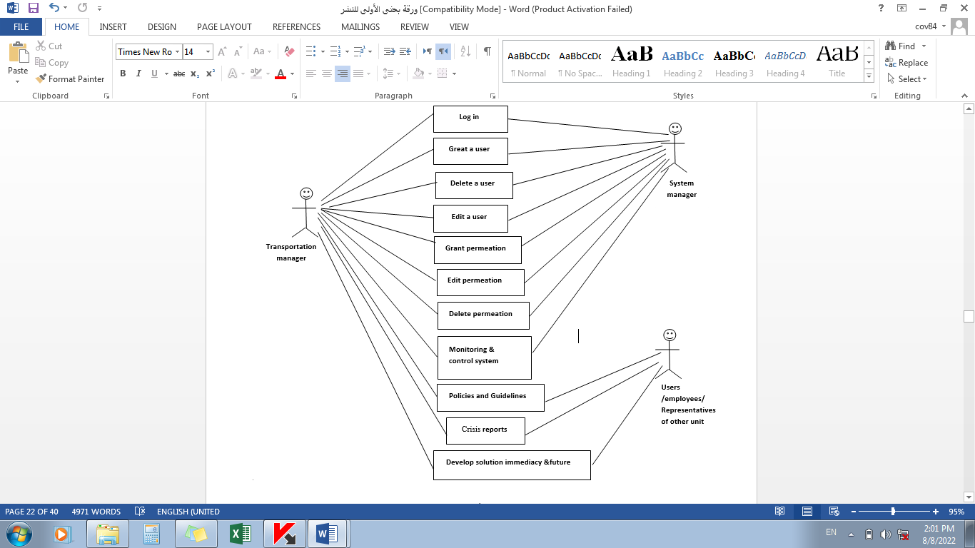
Figure13: The System Manage
- Employees of the Transportation Department:
They are the employees of the transportation Department (ratification employees /accountant), where they enter the system by the reality of the permeation granted to them by the transportation manager and system manager. Then review the data and then make financial receipt and ratification card.
- Director General of the Ministry of Infrastructure, and Transportation :
He is the undersecretary of the Ministry, who Guidance Ministry and follows all the authorities and departments, the system give him a monitor for control transport systems where he has the possibility of directing the transportation manager to remove currant crises and Traffic jam. As well as enable him to direct representatives of other unit, and follow up reports from all sides.
- Roads and Bridges Authority:
It is a authority of ministry transportation& Infrastructure and their representative enter the system through a dedicated user, which he can report to the Transportation manager on the state of roads and public policies of transport, and transfer the directions of Transportation manager to the Road Authority to implement the new transportation lines according to technical studies provided by the Department of Transportation. Also implementing the solutions c provided by transportation manger with Traffic mangement currently and in the future by implementing new roads & bridge.
- Traffic management:
It is a unit of the Ministry of Interior and has a close relationship with the Ministry of transportation &Infrastructure according to the nature of the work between them, where the traffic representative enters the system with a username dedicated to him to conduct that:
- Confirming the vehicle ownership information car lines
- The flow of reports of follow-up traffic jams at peak times or any other crises.
- 3- Reports on the state of parking and of transportation crisis at peak times (morning, afternoon and end of duty).
- The representative of the Traffic Department has transgressive relationships with the Director General and the Roads and Bridges Authority through the Director of the transportation manger (reports, policies and directions).
[5.2] Modeling transportation management system by PHP & Free Geo database:
- System login:
It is the window of access to the program, as figure14 . and through it enters all users of the system and opens screens for them successively according to the premation .
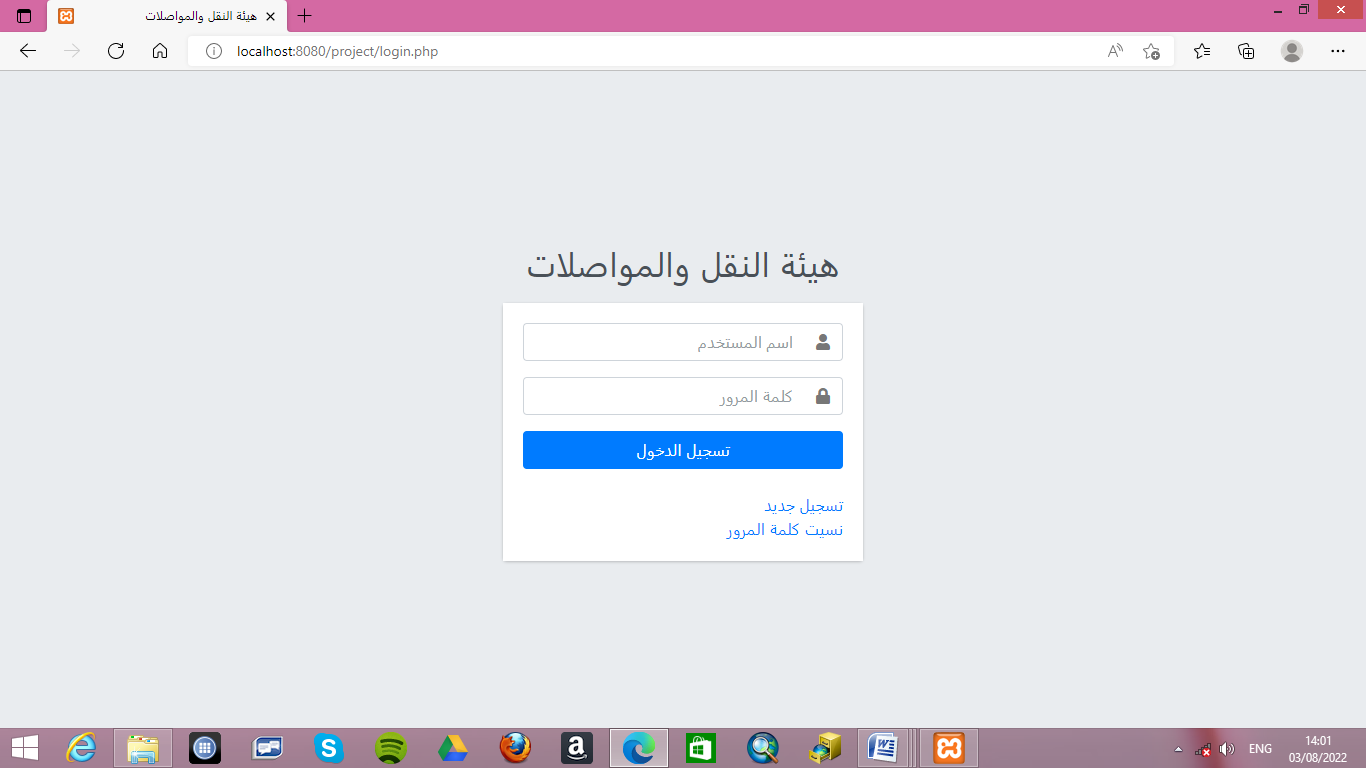
Figure14: The system login
- System main screen:
It is the main screen of the program and includes many of windows , the recording of data, requests, payment of fees ratification and reports of all kinds,as figure15.
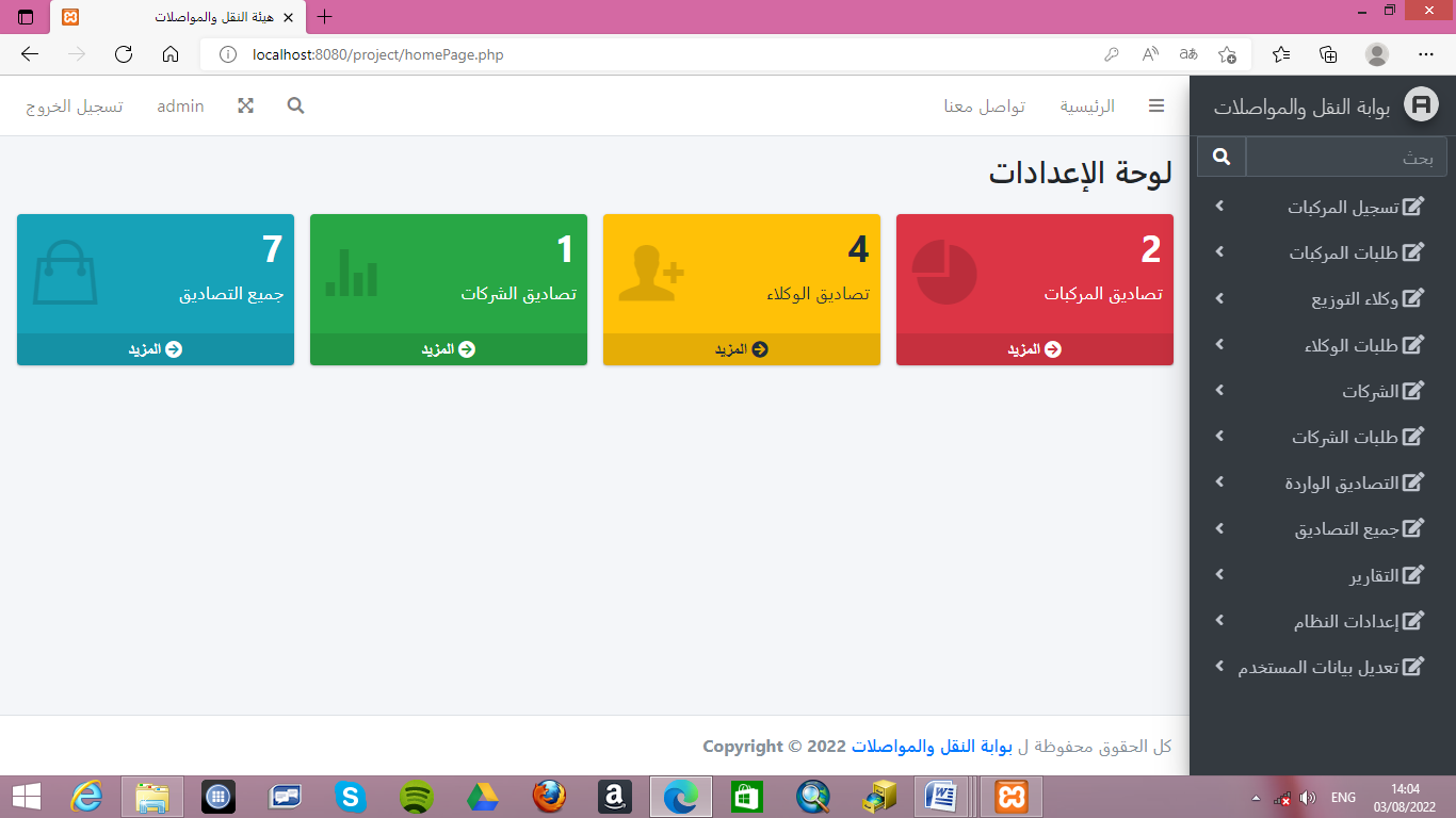
Figure15: The system main screen
- System payment of fees :
It is the financial screen , where the user pays the fees prescribed on him at his request . which the payment is made electronically, it is connected to the operator of of banks in Sudan(API), and in which the validity of the card, and then the required amount is deducted and based on the payment of the fees the user’s request is sent to the window of ratification, as figure16.
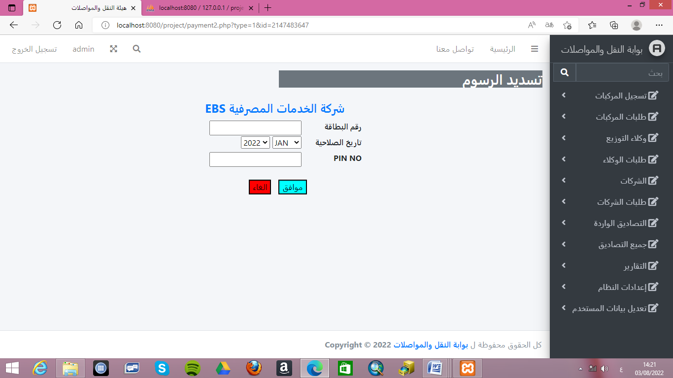
Figure16: The system payment of fees
- System transportaion networt:
It is a window linked with the system to display the transport network with its locations on nature . geographic information systems have been used to download the locations of traffic signals, roads, bridges and parking.Where the map has become a reference for management in monitoring and controlling transport networks in Khartoum State. as figure17.
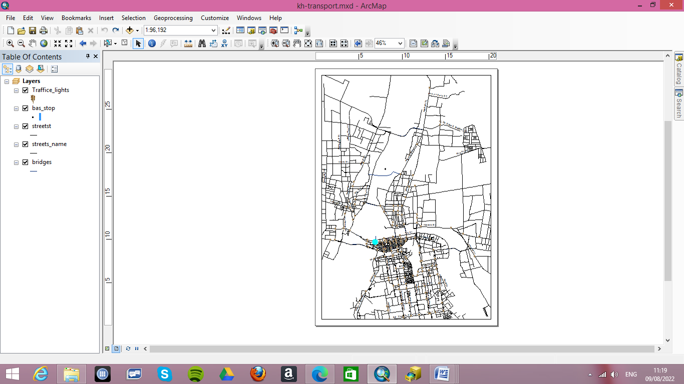
Figure17: The system transportaion networt
- System reports:
It is a screen specialized in all program reports, and includes reports that are used internally in the transportation management, such as (the number of users, the number of requests ratification & not ratification, the status of transportation and their number, the flow of fuel … etc.), reports stating the manager of transportation and the under secretary of the Ministry and representatives of other units such as (parking status reports, traffic signal locations, crises and traffic jams, transport network maps … etc). as figure 18.
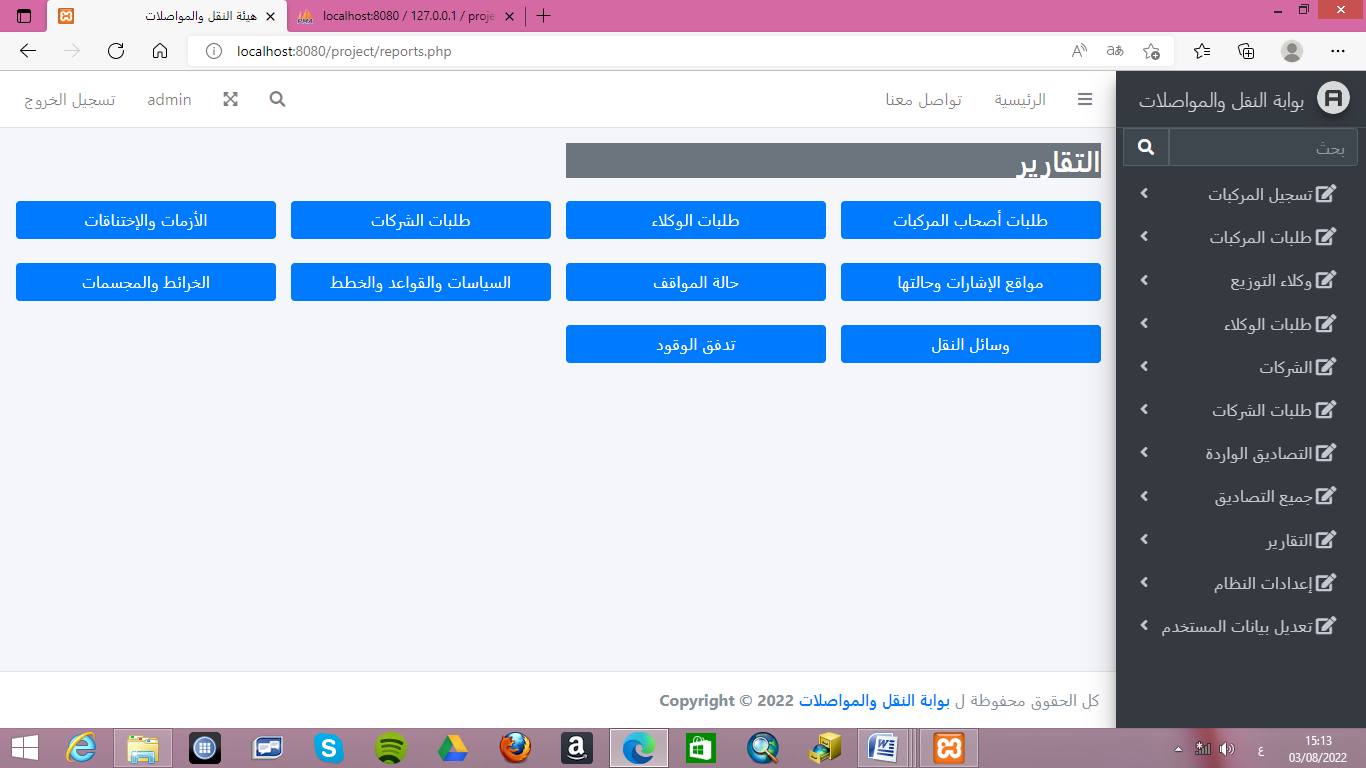
Figure18: The system reports
- The specific or customise reports in system
It is reports window specific or customized to process crises and traffic jam, where it allows the movement of data between representatives of other units (traffic and roads) with the transportation manger and the Undersecretary of the Ministry to benefit from them in solving crises &traffic jam, and using appropriate alternatives, as figure19 . Then a window appears to clarify the administration’s decision to solve crises & traffic jam, as figure20. and also enables this decision to be displayed on the maps of the transport network linked to satellites to control and monitor the transport networks, and allow the test of this decision is it optimal or there is another alternative , as figure21.
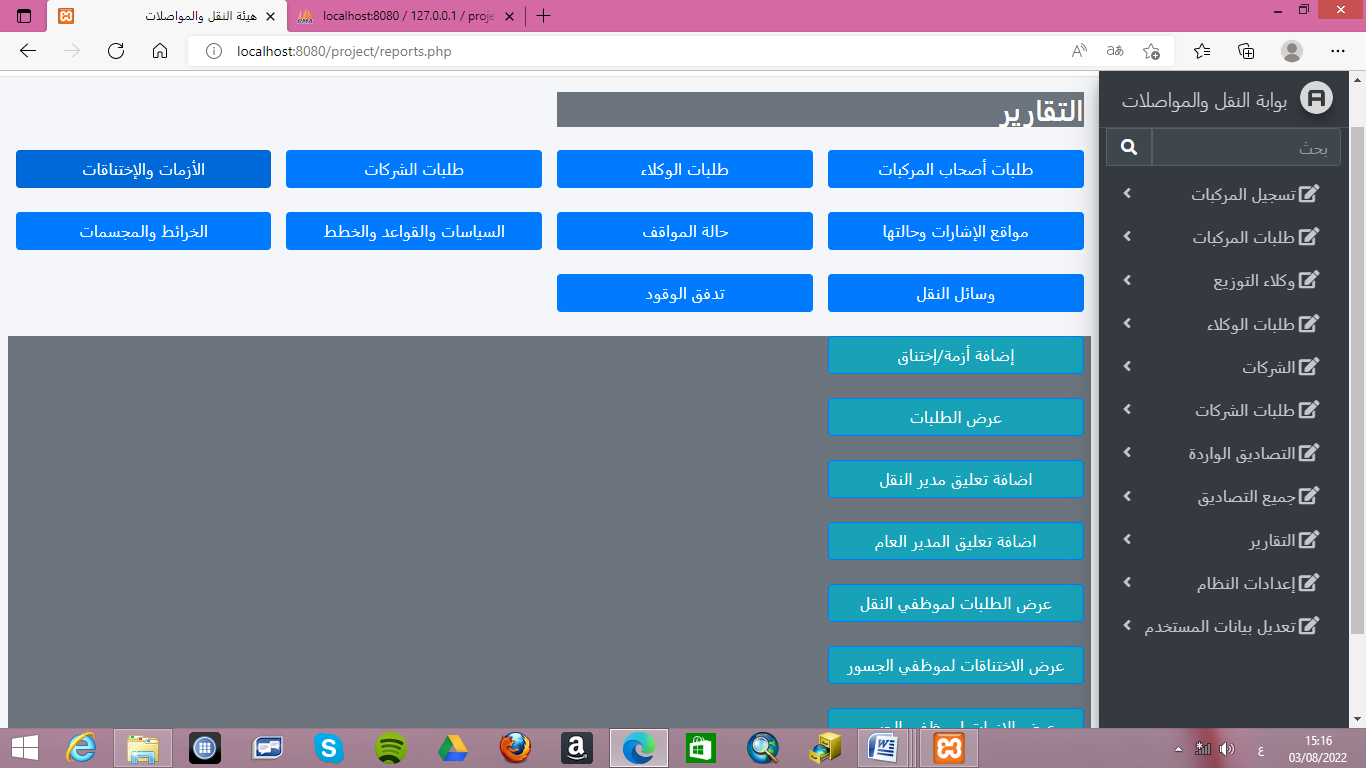
Figure19: The specific or customize reports in the system
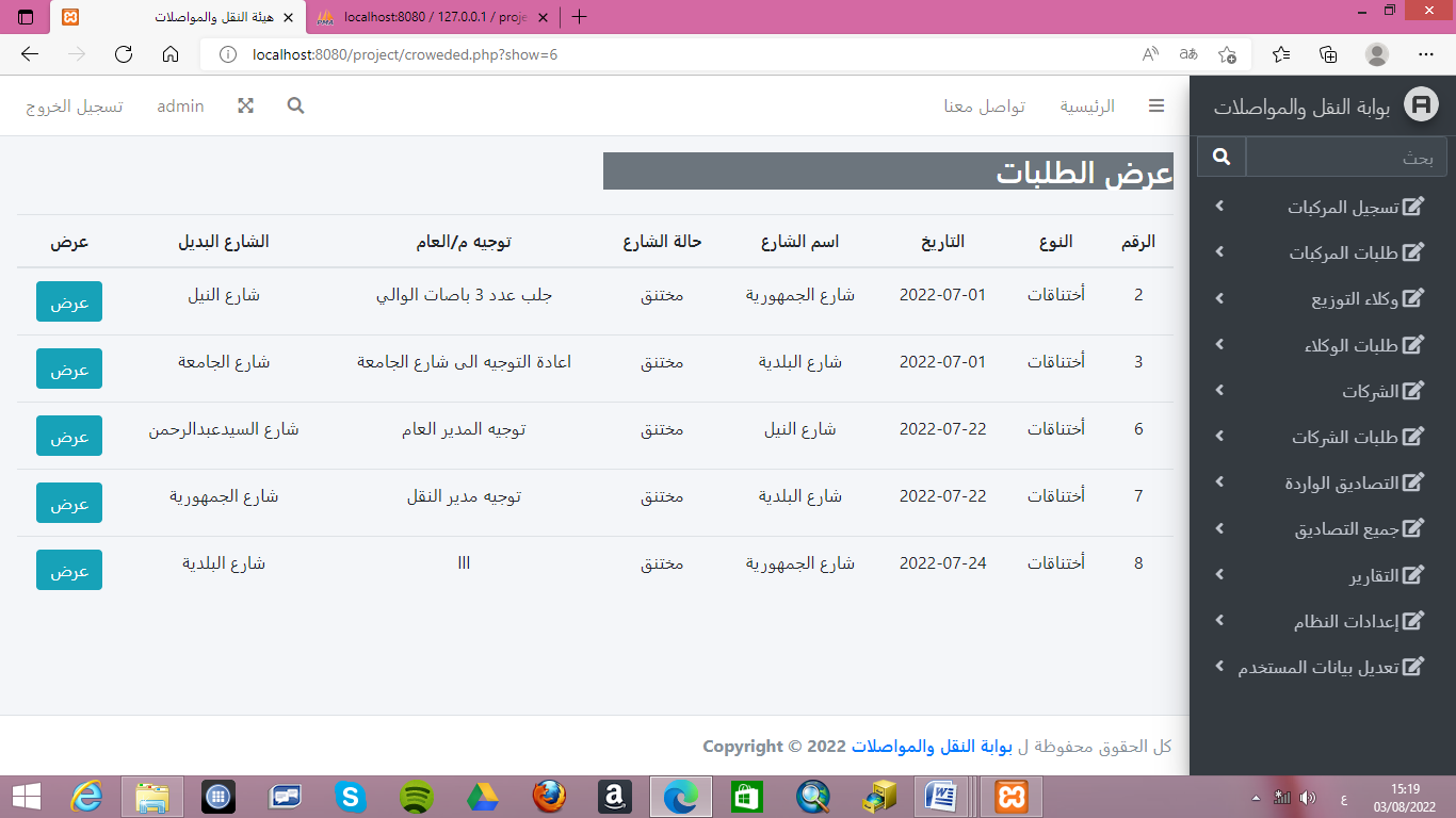
Figure20: View administration’s decision in the system
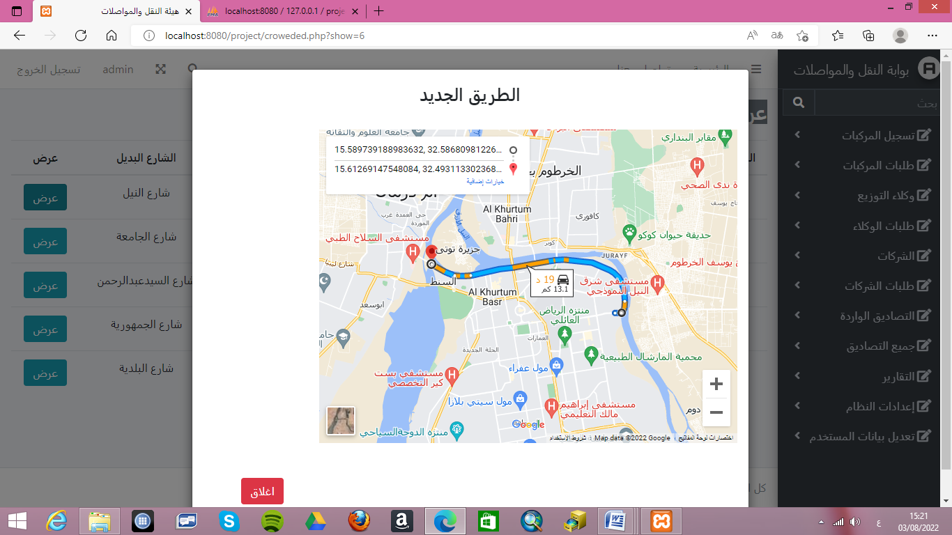
Figure21: View administration’s decision in the map
[6] Contribution of search:
This research has many benefits for society. where we find in other societies effective systems for transport management, while in Sudan there is no clear vision for the management of transport systems and the activation of support for appropriate decision-making at the right time and this is shown in the amount of information that exists and is not optimally utilized , like as transport system currently has many problem : duplication of tasks, increased costs, exhaustion in planning, weak information flows, and overlapping relationships with other ministries, and the client wastes his time in the procedures And the all the work is manual. at the end of search going the following benefits has been : Merge existing knowledge and technology in order to provide decision support tools for management, then is integrated system was designed to computerise system for transportation management , The system made it easier for vehicle owners, agents and company owners to do their work ,and provided the possibility of establishing databases for all transport networks and the roads and traffic signals were linked to their geographical locations on the map , all that helped the management to control& monitoring through their modelling in the map, also provided support higher management in solving traffic crises and jam by changing paths, also provided handling of smoothly between the Transportation manager and the undersecretary of the Ministry , and other relevant units
[7] Conclusion:
The GIS offer a great help to a designer of transportation systems. it is very effective and highly efficient. in this search an integrated system was designed to transportation management so that roads and traffic signals were linked to their geographical locations on the map. This system made it easier for vehicle owners, agents and company owners to do their work electronically so that they saved them effort and time. It also provided the possibility of establishing databases for all transport networks and helped the management to control and operate them through their modelling in the map, and provided support higher management in solving traffic crises and jam by changing paths, eliminate jam and finding suitable alternativesThe system also provided handling of vertically smoothly between the Transportation manager and the undersecretary of the Ministry , and horizontally with the relevant units (traffic, road authority).
Rfrences
- Dr. Al-Mutair, Amer bin Nasser. The Reality of Public Transport by Private Buses in Riyadh. Saudi arabia, 2013.
- Daghfal, Hoda. Studied the use of geographic information systems in preparing the traffic and movement plan for the city of Al-Musliah. Algeria, 2015.
- Ford, Alistair C, Stuart L. Barr, Richard J. Dawson and Philip James. Transport accessibility analysis using GIS: assessing Sustainable transport in london. London, 2015.
- Al-Qarni , Abdullah bin Muhammad. The role of geographic information systems in good traffic management in long roads. Saudi Arabia, 2012.
- Brown. Study of an environmental modeling system based on geographic information systems for transport planners. Australia, 2009.
- Ayad Al-Majdoub ,Engineer Hussein. The use of geographic information systems to download road networks Al-Biruni Center for Remote Sensing. Libya, 2010.
- Nagendira, Sunder. Developing an intelligent GIS network and GPS system for maintenance and rehabilitation system. India, 2011.
- Yildirim, Pedroglio, Population. Determination forest road routes via Gis-based spatial multi-criterion decision methods. Turkey 2018.
- Abu al-Rab , Muhammad ,Ibrahim Waladali. Managing intermittent water distribution networks by using geographic information systems for the city of Halhul. Palestine, 2005.
- Kamal, Mawahib. The effectiveness of using geographic information systems in managing telecommunications services. Sudan, 2016.
- Hat, E.Tgred. GIS applications in electrical networks. Jordan, 2012.
- Abd Al-Ilah, Ahmad, Siddiq Muhammad, Anas Ahmad, Abd al-Rahim Muhammad. The use of geographic information systems in the analysis and design of a sewage network for the Rahmaniyah scheme. Sudan, 2014.
- Sangeetha, Puruchuthaman , Suresh Babu. Estimating the cell phone signal density and determining the most suitable location for the antenna using geographic information systems and remote sensing (RS and GIS). India, 2014.
- Salem, Yasmine Kamel. Applications of Geographical Information Systems (GIS) in Planning. Egypt, 2012.
- Hamdi , Dr.Abu al-Qasim. The use of geographic information systems and their role in managing health disasters. Algeria,2013.
- Al-Ghazi, Subhi. Benefits of using geographic information systems to upgrade work and create infrastructure. Iraq, 2012.
- Okasha , Abdullah Zeian. Lectures Notes “ Kuwait University Faculty of Social Sciences Department of Geography. 2009-2010.
- Al-Shammar , Ahmed Saleh. Geographic information system. First edition, 2007.
- Zain , Muhammad Adam. Research writing methodology. Omdurman Islamic University. Sudan, 2005.
