Salem Elshatshat 1*, Fatima Alsaeh, 2 and Abd Elrahmann El shatshat3
- Faculty of Sciences, Department of Botany, Benghazi University, Libya.
- Faculty of Sciences-Alajelat, Department of Zoology, Zawia University, Libya.
- Faculty of Sciences, Department of Microbiology, Benghazi University, Libya.
*Corrsponding’s auther email: salem.elshatshat@uob.edu.ly
HNSJ, 2024, 5(2); https://doi.org/10.53796/hnsj52/16
Published at 01/02/2024 Accepted at 21/01/2024
Abstract
Cyclones and flooding are massive impacts of climatic changes. In September 2023, Storm Daniel stroked El-Gabal El-Akhdar area, Libya, with windy strong and heavy rain storm (70 – 80 km/h.) and caused flash floods in several cities and valleys (Wadis). This led to catastrophic influences on different levels including soil and vegetation coverage erosion in the area. The research aims to detect the spatial change of vegetation in Wadi AlKuf before and after the storm through the analysis of space visuals using ArcGIS with applications of The Normalized Difference Vegetation Index (NDVI) technique, and other methods. The results revealed that the study area was strongly affected by the storm and because of the heavy soil erosion, a number of different plant species, which form the natural vegetation on the slopes and wadi channel and banks were gone with water run-off. These plants include the following maquis shrub-land like Juniperus phoenicea, Pistacia lentiscus, Arbutus pavarii, Olea europaea, Myrtus communis, Quercus coccifera, Cupressus sempervirens and others which classified on IUCN red list. According to the calculations of the vegetation index (NDVI) and the mapping that reveals the change in the area of vegetation, the vegetative loss was estimated to reach about 30.75 Km2.
Key Words: Libya; Climatic changes; Storm Daniel; vegetation coverage; ArcGIS; NDVI.
INTRODUCTION
Libya is located in North Africa with coastal strip of 1700 km on the Mediterranean Sea. Climatically, it characterized by the Mediterranean climate with hot drought long period summer and warm short rainy winter. The most precipitations are occurred in EL-Gabal El-Akhdar area which lies in the north eastern part of the country with average of 650 ml/year. Because of its ecological and environmental significance, EL-Gabal El-Akhdar (The Green Mountains) was considered to be one of the most important topographical phenomena in Libya (Qaiser and El-Gadi, 1984), which also included desert, wadis and prairies.
Climatic changes are having a massive impact in many areas of the world, this includes increased temperatures, drought, deforestation, cyclones and flooding. In 2005, Kerry Emanuel proposed and released for the first time the term “Medicanes” which referred to an amalgamation of the words Mediterranean and hurricane that characterized by high speed wind and heavy rainfalls and such this medicanes is Storm Daniel. However, in Libya, a weather system like Storm Daniel was unprecedented. Thus, it affected and influenced everything stroked.
According to Libya’s National Meteorological Centre (LNMC), the windy strong and heavy rain storm (70 – 80 km/h.) reached EL-Gabal El-Akhdar on 10th September. This led and causing catastrophic damage like communications interruption, the fall of electricity towers and trees, dams collapsed, and on the humanitarian side at least 4,333 people were killed. Torrential rains of between 150 – 240 mm caused flash floods in several cities, including Al-Bayda, which recorded a new rainfall record with the highest daily rainfall rate of 414.1 mm/24h (LNMC). This rate is equal that which precipitate in year.
In Libya, precipitation and water runoff are the important hydrologic component in the water resources like valleys (Wadis), especially in El-Gabal El_akhdar which reached more than 30 wadis with different long, area and water capacity among them (Wadi Al kuf as an example). They represent a vital habitat for plants differs from other adjacent habitats that affecting vegetation density. Libyan flora is consisting of around 2000 plant species and most of them (more than 50%) are occurring in El-Gabal Al-Akhdar area (Cyrenaica district) (Qaiser and A. El-Gadi 1984). During the past years, different studies were conducted to explore the Libyan flora and vegetation cover, especially of wadis (Ali & Jafri 1977; Asker 1998; El-Darier and El-Mogaspi, 2009; El-Barasi, et al., 2003; El shatshat et al., 2009; Alaib et al., 2017; Al-Traboulsil, and Alaib 2021).
Wadi Al kuf is covered with the most of 50% of Libyan flora (Ammar 2019). Slopes and banks of the wadi are covered with dense chaparral vegetation consisting of several species such as the following maquis tree like forms: Juniperus phoenicea, Cedrus atlantica (cultivated), Pistacia lentiscus, Arbutus pavarii, Olea europaea, Myrtus communis, Quercus coccifera and Cupressus sempervirens, (Qaiser and A. El-Gadi 1984).
Detection the spatial changes of vegetation using GIS and NDVI is taking place during last years. Many studies were used these technics and revealed the changes due to different factors like human activities, climatic changes, desertification and others that affecting the vegetative cover (Gandhi et al., 2015; Sadek et al., 2020; Hussein and Alnajim 2020).
Because of Storm Daniel, the Wadis (seasonal rivers) of the area were overflowed their banks by high level of water (for example, wadi Derna was 50 metres on each side). This caused heavy and strong water flow and run-off in wadi channels, and respectively, erosion of soil and plants. In this study, we tried to shade some light on the ecological impacts of Storm Daniel on Wadi alkuf vegetation and estimate the vegetative loos using the assessment of vegetation by Geographic Information System (GIS) and Remote Sensing (RS), in addition, applications of The Normalized Difference Vegetation Index (NDVI) technique.
MATERIAL AND METHODS
Study area: Wadi Al Kouf area is a valley located in north eastern part of Libya and it is far around 18 Km north-west of Al-Bayda city. It lies between latitudes 32.5ºN and 32.8ºN and longitudes 21.4ºE and22.00ºE, and it starts gradually from the north coast to south with elevation of 0 m to 800 m above main sea level, with total area about 950 Km2 (Figure 1). This wadi is characterizing with rocky low cliff formation on both side (banks) of the valley (ben Amer & Shakman, 2013).
Data analysis: the data before and after Storm Daniel were collected and divided in two parts; the first part was to evaluate and analyze data using ArcGIS with applications of The Normalized Difference Vegetation Index (NDVI) technique. It was used for extracting the various features presented in the Satellite images of Wadi Alkuf area. The second part is collecting data and using available information, literatures, references and different visits to the study area. The comparisons between the available data before and after the storm were used to estimate the vegetative loos.
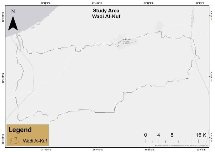
Figure 1, The location of study area Wadi Al-kuf
RESULTS ND DISCUSSION
As shown in figure 2, 3, and 4, the field visits to the study area revealed the devastation caused by the catastrophic flooding. Clearly the rainfall associated with Storm Daniel was extreme and there is no doubt that the magnitude of the damage indicates that a rainfall-induced river flood was formed. This large total might have exceeded the Wadi structure which naturally is not adapted to like this climatic changes and subsequently, avoid serious damage.
Water-induced soil erosion high values were observed in the study area that exposed to heavy rains (Figure 4). Despite the soil erosion varied from low to high erosion, but here, the effects of Storm on soil were very high while a Hugh number of tons of soils and sediments transport in highly variable spatially processes (Figure 4). Even though the vegetation coverage in the Wadi channels and on the side banks before the flooding was characterized as aged, rough and dense, but this could not prevent the erosion (Figure 2). The most likely scenario is, that storm-flow behave as overwhelmed and releasing a torrent of water and sediment downstream.
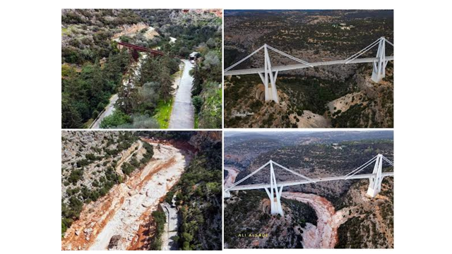
Figure 2. The catastrophic effect of Storm Daniel on Wadi Al kuf area from different locations. Left up, the wadi with the old bridge which established during Italian occupation before the flooding, and down, the devastation caused by the catastrophic flooding. Note the absence of the bridge, roads and vegetation. Right up the wadi new bridge. Note the differences between before flooding “up” and after flooding “ down”. Photos were caputured by the Libyan photographer Ali Al saadi (Al saadi, A., personal communication, October 10, 2023).
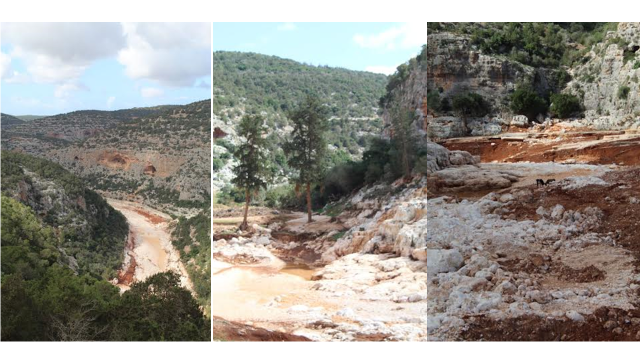
Figure 3. The erosion and absence of vegetation from Wadi channel, banks and slopes of the mountain.
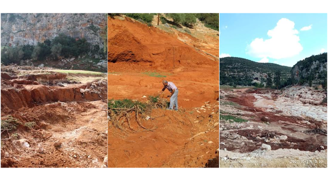 Figure 4. The soil erosion of the channel and banks of Wadi Al kuf. appearance of white rocks and eroded alluvial soil is clearly notable
The results of Satellite images and NDVI analysis showed that the vegetation of study area was affected by Storm Daniel. There was a clear change in the size, density, spread and distribution of vegetation cover in the area before and after the flood. The range of NDVI values ranged between (- 0.50) and (0.66) before the flood, while they were (- 0.37) and (0.535) after the flood (Figure 2). This reflected to what extent the storm influenced the area, especially in Wadi channels and banks which appeared as light color in the mettle of figure 5 after the storm.
According to USGS Remote sensing phenology, the NDVI values were classified to three classes; very low, moderate, and high NDVI (Table 1). From the results of NDVI calculations and analysis, it is clear that the vegetation coverage is consists of values of 0.66 and 0.535 which pointed to moderate and high dense vegetation like trees or sparse vegetation such as shrubs and grasslands. This reflect that the shrubs and trees was formed the most vegetative coverage in the study area. On the other, the low values (-0.5 and -0.37) were reflected areas with very low vegetation.
The study revealed that both high and low NDVI values were decreased after the flood with factor of (0.129) and (-0.130), respectively. The calculations of the vegetation index (NDVI) and the mapping indicated to the change in the area of vegetation and the vegetative loss was estimated to reach about 30.75 Km2.
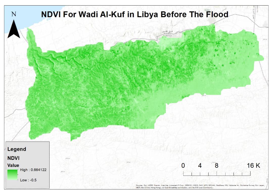
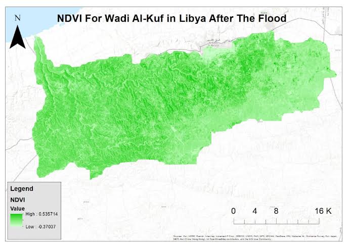
Figure 5. The effect comparison of pre-flood (top) and post-flood (bottom) on the vegetation of wadi Al-Kuf area.
Table 1. The classification of NDVI values according to USGS Remote sensing phenology.
Floods are a significant environmental threat for plants (Pucciariello et al., 2014). Plants form the coverage or grow on the Wadi channel and the banks like Juniperus phoenicea, Cedrus atlantica, Pistacia lentiscus, Arbutus pavarii, Olea europaea, Myrtus communis, Quercus coccifera and Cupressus sempervirens, were also eroded through the water run-off. Due to rich vegetation of Al-Kuf valley (Wadi), and its floristic composition, a number of plants which mentioned as medicinal value (Al-Traboulsil and Alaib 2021), threatened or endemic plants (El-Darier and El-Mogaspi, 2009; AL rishi 2022) are most strongly influenced. Table 2 shows plant species including endemic and medicinal plants which thought to be affected by different degrees of devastation.
The location, topographic structures, environmental and climatic characteristics were offered a good growth conditions for a specific number of plant and animal species and, of course, these factors played a major role in richness and biodiversity of Wadi Al-Kuf compare to the rest of El-Gabal Al-Akhdar area especially adjacent valleys. Therefore, it had chosen in 1979 to be protected area for wild life with an area of 9000 hectares (Ben Amer & Shakman, 2013). According to the International Union for Conservation of Nature (IUCN, 2016; IUCN, 2021) and some local reports (El shatshat et al., 2009; El-Barasi & Saaed, 2013; Mosallam et al., 2017), different plant species were listed on the Red List or locally classified as critical with a different ranking. This include for example plants such as Juniperous phonicea L., Arbutus pavarii Pamp., Cupressus sempervirens L. var. horizontalis (Mill) Gord.
The findings of different studies, reported that the biological spectrum of Libyan flora consists of a number of life forms which described by Raunkeir, but the annuals and perennials are common and dominant (El shatshat and Mansour 2014; Alaib et al., 2016, Al-Traboulsi1 and Alaib 2021). This also clearly was found in Wadi Al-kuf and reflected the climatic conditions in the study area. The trees and shrubs (Perennials) can avoid the dry summer period by their sclerophyllous morphological or physiological characteristics, while the annuals to preserve their genetics, escape from unsuitable conditions as seeds in or on the soil forming the seed bank. Unfortunately, the most seed banks of the area were eroded by the flood and this might lead to an imminent danger of genetic erosion, especially for the endemic plants occurred in the area (Table 2), which form more than 50% of the total endemic species of Libya (Qaiser and El-Gadi, 1984), in addition, plant species with ethnobotanical values (Al-Traboulsi1 and Alaib 2021). At the present, the picture about amounts and species is not clear enough, therefore, further work for seed banks is highly recommended.
A number of studies reported the relationship between channels vegetation and their flow conditions in both humid and dry land channels (Stromberg et al. 2006; Sandercock et al. 2007; Reynolds and Shafroth 2017; Feizbahr et al. 2021 and Riis and Biggs 2003). Sandercock et al., (2007) showed that the vegetation of dryland channels differs from humid channels because the major woody plants are phreatophytes which characterized with very long taproots.
Table 2. Some plants form vegetation coverage of Wadi Al-kuf including the endemic, forage and medicinal plants which mentioned on IUCN red list like Arbutus pavarii and others.
| Plant species | Family |
| Arum cyrenaicum Hruby. | Araceae |
| Anthemis cyrenaica Coss. var. cyrenaica | Asteraceae |
| Anthemis cyrenaica Coss. var radiata Pamp. | Asteraceae |
| Anthemis taubertii Durand & Barratte. | Asteraceae |
| Bellis sylvestrsis var.cyrenaica Beg. | Asteraceae |
| Onopordum cyrenaicum Maire&Weill | Asteraceae |
| Convolvulus maireanum Pamp. | Convolvulaceae |
| Arbutus pavarii Pamp. | Ericaceae |
| Medicogo cyrenaica Maire& Weill. | Fabaceae |
| Trifolium cyrenaicum Pamp. | Fabaceae |
| Ballota andreuzziana Pamp. | Lamiaceae |
| Nepeta cyrenaica Quezel&Zaffran | Lamiaceae |
| Plantago cyrenaica Durand & Barratte. | Plantaginaceae |
| Libyella cyrenaica (Durand & Barratte) Pamp. | Poaceae |
| Poa pentapolitana H. Scholz | Poaceae |
| Allium negrianum Maire&Weiller. | Alliaceae |
| Allium ruhmerianum Asch. | Alliaceae |
| Athamant della- cellae Asch. | Apiaceae |
| Ferula marmarica Aschers | Apiaceae |
| Anthemis taubertii Durand & Barratte. | Asteraceae |
| Cynara cyrenaica Maire & Weill | Asteraceae |
| Echinops cyrenaicus Durand & Barratte | Asteraceae |
| Onopordum cyrenaicum Maire&Weill | Asteraceae |
| Nonea viviani DC. | Boraginaceae |
| Onosoma cyrenaicum Durand & Barratte | Boraginaceae |
| Ranunculus cyclocarpus Pamp. | Ranunculaceae |
| Linaria laxiflora Desf.ssp.calcarlongum Qaiser | Scrophulariaceae |
| Teucrium apollinis Maire& Weiller | Lamiaceae |
| Teucrium barbeyanum Asch. | Lamiaceae |
| Teucrium davaeanum Coss. | Lamiaceae |
| Teucrium zanonii Pamp | Lamiaceae |
| Orobanche cyrenaica Beck. | Orobanchaceae |
| Cyclamen rohlfsianum Aschers | Primulaceae |
Bendix (1999) showed that number of factors such as stream power, elevation and valley width are playing major role in the effect on vegetation in water channels. In arid and semi-arid zones, with only occasional flow of water, the vegetation grows within the channel and the floodplain (Hooke 2023). Vegetation along the water channels increases the roughness (Hooke 2023, and Gholami and Khalegi 2013) and reduces flow energy and velocity (Azab et al., 2021). The roughness of vegetation coverage in such this area has a great effect on flow resistance during flood, and resistance against the flow depends on the flow conditions and plants (Azab et al., 2021). Unfortunately, the vegetation composition in the wadi could not standing (Figure 3) because of high flow stream power of Storm Daniel, even though it had the morphological features of the resistance and patterns of species richness along wadi channel and banks (Tabacchi et al. 1996).
According to the location of the study area as a semi-arid zone, the water stream and flow was very low during last four decades. This caused reduction of flow magnitudes which mostly leading to channel narrowing. The uneven distribution of little rainfalls of El-Gabal El-Akhdar area, Libya, caused water scarcity and some plants faced drought stress and phenomenon of die-back was appeared on different plant species like Juniperous phonicea L. Therefore, a number of plant species were mentioned and classified on red list of IUCN.
Vegetation Cover is one of most important biophysical indicator to soil erosion, which can be estimated using vegetation indices derived from the Satellite images. Repetitive and seasonal flash floods, occur in different countries like those in Mediterranean and north Africa (Hallouz et al., 2018; Almasalmeh et al., 2022; Azab et al., 2021), entails the soil layer by erosion and carry spatially large quantities of water and soil sediments (Singh et al. 2020). Azab et al., (2021), found that more than 5500 ton of sediments of Wadi Naghamish (Egypt) reached the wadi outlet. And the highest values were found in the sloping areas. Despite the flood is un-repetitive, this finding can be noticed in Wadi Al-Kuf (Figure 3 and 4).
Plants form the greatest habitat for a number of other organisms like wildlife animals. They provide a place to live, shelter, safety and food. Areas dominated by dense vegetation include herbs, grass lands and trees, might offered the suitable ecosystem for their life’s and this affects as well their reproductive success and behavior patterns. The animals that live in a particular area, are greatly affected by the intensity natural disturbances and human activity. Due to the flood in Wadi Al-Kuf, the situation of wildlife fauna has become very difficult and more critical, because a number of plants which serve as habitat were destroyed and of course, a number of animals were directly killed or eroded by the flood.
One of major problems of fauna studies in Libya is scarcity and lack of information about the abundance and distribution of wildlife animals especially in El-Gabal Al-Akhdar. Some attempts from local researchers were tried to shade some light on some wild animals and their locations, fortunately, this includes wadi Al-Kuf. Al-Awami (1997), Abrahim (2009), Abd Elhamid (2012), Muhammed et al., (2018) and Algadafi (2019) reported that some wild animals were faced threats. according to the Red List of IUCN, Hyaena hyaena is listed as near threatened while others were on different levels of assessment (Table 3). It is important to note that habitat destruction is major threats to wildlife and therefore, fully recover takes time.
Table 3. wild animals of EL-Gabal El-Akhdar area and their assessment according to IUCN. Data from different resources.
| Species | Family | IUCN assessment | ||||
| Canis anthus variegatus | Canidae | LC | ||||
| Canis aureus | Canidae | LC | ||||
| Hyaena hyaena | Hyaenidae | LC | ||||
| Hemiechiusauritus | Erinaceidae | LC | ||||
| Jacusis jacusis | Jaculidae | LC | ||||
| Jaculus jaculus jaculus | Jaculidae | LC | ||||
| Lepus capeasis barceus | Leporidae | LC | ||||
| Lepus capenasis | Leporidae | LC | ||||
| Spalax ehrenbergi | Spalacidae | DD | ||||
| Hystrix cristata | Hystericidae | LC | ||||
| Mus musculus | Muridae | LC | ||||
| Atelerix algirus | Erinaceidae | LC | ||||
| Lynx (Felis) caracal | Felidae | NT | ||||
| Caracal caracal | Felidae | NT | ||||
| Felis lybica | Felidae | LC | ||||
| Genetta genetta | Viverridae | LC | ||||
| Microtus guentheri | Cricetidae | LC | ||||
| Lctonyx libycus | Mustelidae | LC | ||||
| Vulpes vulpes | Canidae | LC | ||||
| Lepus whitakeri | Leporidae | LC | ||||
| Allactaga tetradactyla | Dipodidae | DD | ||||
| Pachyuromys duprasi | Muridae | LC | ||||
| Pipistrellus kuhli | Vespertilionidae | LC | ||||
| Rattus norvegicus | Muridae | LC | ||||
| Eliomys quercinus | Gliridae | NT | ||||
| Herpestes ichneumon | Herpestidae | LC | ||||
| Vulpes vulpes aegyptica | Canidae | LC | ||||
Wadi Al-Kuf suffered a lot from Storm Daniel which removed the soil layers, destroyed natural vegetation, infrastructures as well as influenced the wild life. Because the storm stroked all the area of El-Gabal Al-Akhdar, and caused the same effects, this picture can imagine on other valleys with the same or different significant danger level. Thus, special consideration is required for the whole area and particularly Wadi Al-Kof. More studies and research to determine the eroded soil quantity and specific plant species, seed banks loss, wild life, rebuilt the infrastructure and the channels plans must take in account. In addition, the vegetation coverage rehabilitation programs using indigenous native species that tolerate more other ones, like Ceratonea silique L. should carefully studied.
References
Abd Elhamid, A., M. (2012). Biodiversity in the Green Mountain Region in the Libyan Arab Jamahiriya, a study in environmental geography “in Arabic”, Arab Geographical Journal, Egyptian Geographical Society, Geographical Research Series, No. 40, 2-90.
Abrahim, M. (2009) The deterioration of wildlife in the Jabal Akhdar region and the potential for its development “in Arabic”, Al-Mukhtar journal for humanitarian sciences, El-bieda, Libya.
Alaib, M. A., Elbakkosh, A. M., Abdulati, Y. B., Gadelmola, A. S. & Elmhafdi, A. M., (2016). Preliminary investigation of the vegetation of Wadi Belkaf-Bata, Al-Jabal Al-Akhdar. Libyan Journal of Science 4(1), 20–27.
Alaib, M., El-Sherif, I. & Al-Hamedi, R., (2017). Floristic and ecological investigation of Wadi Al-Agar in Al-Jabal Al-Akhdar, Libya. Journal of Science and its applications 5(1), 57–61.
Al-Awami, A., M. (1997). Libyan wild animals “in Arabic”, Omar Al-Mukhtar University Publications, Al-Bayda, Libya. In arabic.
Algadafi, W. (2019). The conservation ecology of the Dorcas gazelle (Gazella dorcas) in north east Libya, Doctor of Philosophy, University of Wolver Hampton.
Ali, S. I. & Jafri, S. M., (1977). Flora of Libya. Vols. 1–24. Department of Botany, Al-Fateh University, Tripoli, Libya.
Almasalmeh, O., Saleh, A. and K. Mourad (2022). Soil erosion and sediment transport modelling using hydrological models and remote sensing techniques in Wadi Billi, Egypt. Modeling Earth Systems and Environment, 8:1215–1226 https://doi.org/10.1007/s40808-021-01144-1
AL rishi, N. (2022). Distribution and habitats of endemic flowering plants at El-Gabal El-Akhdar area, MSc. Thesis, Acadamy of higher studies, Benghazi, Libya.
Al-Traboulsil, M. and M., Alaib (2021). A survey of medicinal plants of Wadi Al-Kouf in Al-Jabal Al-Akhdar, Libya, NAT. CROAT., 30 (2) 389–404. DOI 10.20302/NC.2021.30.25.
Ammar, A. (2019). The Influence of the Lineament Geological Features on the Hydrologic Flow Direction of Wadi Al Kuf Catchment Area, Cyrenaica, Northeastern Libya, Al-Mukhtar Journal of Sciences 34 (3): 197-288.
Asker, A. M., (1998). Vegetation and flora of Wadi Al-Ashrha (Al-Jabal Al-Akhdar). M. Sc. Thesis. University of Garyounis, Benghazi, Libya.
Azab, Y., Abbas, H, Jalhoum, M., Farid, I., Abdelhameed, A. and E. Mohamed (2021). Soil erosion assessment in arid region: A case study in Wadi Naghamish, Northwest Coast, Egypt, The Egyptian Journal of Remote Sensing and Space Science, 24:(3), 1111-1118.
Ben Amer, I. & Shakman, E. (2013). Economic and Social survey of El kouf National Park in Libya. Med MPA net project, Tunis.
Bendix J, 1999. Stream power influence on southern California riparian vegetation. J Vegetat Sci. 10:243–252.
El-Barasi, Y., El-Sherif, I. & Gawhari, A., (2003). Checklist and analysis of the flora and vegetation of Wadi Zaza at Al-Jabal Al-Akhdar (Cyrenaica, Libya). Bocconea 16, 1091–1105.
El-Barasi, Y. & Saaed, M., (2013). Threats to plant diversity in the North Eastern part of Libya (El-Jabal El-Akhdar and Marmarica plateau). Journal of Environmental sciences and Engineering 2, 41–58.
El-Darier, S. M. & El-Mogaspi, F. M., 2009: Ethnobotany and relative importance of some endemic plant species at El-Jabal El-Akhdar region (Libya). World Journal of Agricultural Sciences 5(3), 353–360.
El shatshat S., G,Thabt, and N. Elhashani (2009). Critical situation of the vegetation of EL-Gabal EL-Akhdar area: Physical and anthropogenic factors and their effects on wild utilized and endemic taxa, International Journal of Sustainability Science and Studies,1: 60-63
El shatshat, S. and A. Mansour (2014). Disturbance of flora and vegetation composition of Libya by human impacts: Costal Region of Al-Jabal Al-Akhdar area as model, Advances in Applied Science Research, 5(5):286-292.
Emanuel, K. (2005). Genesis and maintenance of “Mediterranean hurricanes”, Advances in Geosciences, 2, 217–220.
Feizbahr, M., Tonekaboni, N., Jiang, G. and H., Chen (2021). Optimized Vegetation Density to Dissipate Energy of Flood Flow in Open Canals, Mathematical Problems in Engineering, 1-18. https://doi.org/10.1155/2021/9048808
Gandhi, M., Parthiban, S., Thummalu, N. and A. Christy (2015). Vegetation change detection using remote sensing and gis – A case study of Vellore District. Procedia Computer Science, 57, 1199 – 1210.
Gholami V., and M. Khalegi (2013). The impact of vegetation on the bank erosion (Case study: The Haraz River). Soil & Water Res., 8: 158–164.
Hallouz, M., Medii, M., Mahe, G., Toumi, S. and S. Rahmani (2018). Erosion, Suspended Sediment Transport and Sedimentation on the Wadi Mina at the Sidi M’Hamed Ben Aouda Dam, Algeria. Water 2018, 10(7), 895; https://doi.org/10.3390/w10070895
Hooke, J. (2023). Flood impacts on vegetation and hydraulics in ephemeral channels and dynamics of recovery, Journal of Ecohydraulics, (8): 2, 89–104,
https://doi.org/10.1080/24705357.2023.2189168.
Hussein, E., and A., Alnajim (2020). Digital Processing of Changing Vegetation Coverage in Kufa District using Arc GIS, Journal of arts, literatures, humanities and social sciences, (58). DOI: 321-339. 10.33193/JALHSS.58.2020.254
Libya’s National Meteorological Centre (LNMC) (2023). daily reports of September.
IUCN (2016). The IUCN Red List of Threatened Species. https://www.iucnredlist.org.
IUCN (2021). The IUCN Red List of Threatened Species. https://www.iucnredlist.org.
Mosallam, H., Hashim, S. and Sergiwa, S., (2017). A size distribution of some endangered plant species, Al-Jabal Al-Akhdar, Libya. Egyptian Journal of Botany. 57(1), 181–197.
Muhammed, R., Fadlallah A., Abdullah, H. and O. Al-Naji (2018). Classification of wildlife and the causes of their deterioration in the Jabal Akhdar region “in Arabic”, Journal of the Modern University of Benghazi for Sciences and Human Studies, 2, 1-30.
Reynolds LV, Shafroth PB. (2017). Riparian plant composition along hydrologic gradients in a dryland river basin and implications for a warming climate. Ecohydrology. 10(6). https://doi.org/10.1002/eco.1864.
Riis, T and B., Biggs (2003). Stream vegetation and flow regimes, Water & Atmosphere, 11(1), 18-20.
Pucciariello, C., Voesenek, L., Perata, P., and R. Sasidharan (2014). Plant responses to flooding, Frontiers in Plant Science. 5(150):226. DOI: 10.3389/fpls.2014.00226
Qaiser, M. and A. El-Gadi, (1984). A critical analysis of the flora of Libya. Libyan Science Journal, Libya, 13: 31-40.
Sadek, M., Li, X., Mostafa, E., Freeshah, M., Kamal, A., Almouctar, M., Zhao, F., and E. Mustafa (2020). Low-Cost Solutions for Assessment of Flash Flood Impacts Using Sentinel-1/2 Data Fusion and Hydrologic/Hydraulic Modeling: Wadi El-Natrun Region, Egypt, Advances in Civil Engineering, 1-21. https://doi.org/10.1155/2020/1039309
Sandercock PJ, Hooke JM, Mant JM. (2007). Vegetation in dryland river channels and its interaction with fluvial processes. Progress Phys Geograph. 41:107–129.
Singh A, Kumar S, Naithani S (2020). Modelling runof and sediment yield using GeoWEPP: a study in a watershed of lesser Himalayan landscape. India Model Earth Syst Environ. https://doi.org/ 10.1007/s40808-020-00964-x
Stromberg JC, Lite SJ, Rychener TJ, Levick LR, Dixon MD, Watts JM. (2006). Status of the riparian ecosystem in the upper San Pedro River, Arizona: Application of an assessment model. Environ Monit Assess. 115(1–3): 145–173.
Tabacchi E, Planty-Tabacchi AM, Salinas MJ, Decamps H. (1996). Landscape structure and diversity in riparian plant communities: a longitudinal comparative study. Regulat River Res Manage. 12:367–390.
