Characteristics of the Traditional Techniques Used in the Management of Water Resources in the semi arid Doukkala Area (Morocco)
Dr: Youssef El aoud1*
1* Department of Geography, Le Laboratoire Recomposition de L’espace et Développement Durable (REDD), FLSH Chouaib Doukkali University, El Jadida 24000, Morocco.
Corresponding email: youssef10elaoud@gmail.com :
HNSJ, 2024, 5(9); https://doi.org/10.53796/hnsj59/8
Citation Methods
Published at 01/09/2024 Accepted at 11/08/2024
Abstract
The Doukkala area is located in the central Atlantic in Morocco. It is characterized by a semi-arid climate as it is penetrated by seasonal valleys taking its crucial source from the Rehamna plateau. Doukkala is divided into four territorial parts: The oulja part, the Sahel, the interior plain and the south-eastern margins. They definitely differ in terms of development. Doukkala area basically depends on Bour agriculture, that is to say it gets the water resources from the precipitation. Moreover, it depends on irrigation agriculture which comes from Oum Errabia valley. Doukkala area is inhabited by nine tribes that cope with the milieu characteristics. The natural milieu of Doukkala is a significant factor to create as to adopt a various techniques used in the management and the mobilization of water resources by the local population.
The local population has managed the surface water resources provided by the seasonal valleys locally named the flood phenomenon; this technique draws on various traditional techniques such as “The Rabta”, “The Hancha”, “The Karaja” or water intake and “The Canal soil”. The local population has found out “The Natfiya technique” to mange and mobilize precipitation water.
The local population has used various traditional techniques such as” The Oglat”, “The Aghrour well”, “The traditional well” to manage the underground so as to provide domestic water, irrigate some of the tree planting and last but not least the cattle’s fatal needs of water.
These techniques and methods used in managing water resources has had economical, social and environmental implications.
Key Words: the Doukkala area, management and mobilization, water resources, the drought, the scarcity.
The Doukkala area is characterized by the scarcity of water resources, semi-arid climate and diversity of surface topography. Doukkala area is well known by that augmenting demand for water in agricultural activities and that of domestic water.
The local population has actually created and innovated various traditional techniques and methods to adapt with the natural milieu of Doukkala. Utilising these techniques has been an adequate solution in order to face those constraints having just been mentioned beforehand.
Using these traditional techniques in semi-arid area is definitely to ensure having that expected stability of human beings in their daily basis, and to achieve that economic and social equilibrium. In fact, using these techniques is much effective in spite of the simplicity when it comes to the construction. Basically, this has economical and social implications on the population locally as environmentally.
This paper aims at explaining the drought types, the characteristics of the traditional techniques in Doukkala area and the economical and social implications.
2. Study Area and Data
2.1 Study Area
The Doukkala is located in the centre of Morocco as it is one of the most important coastal areas in this country. Doukkala is characterized by a semi-arid climate and irregular precipitation at a rate of 266 mm according to a 36 year climate series[[1]]. Doukkala is has got seasonal valleys taking its source from the Rehamna plateau: The Aouja, Souani, and Bouchane, etc. The water of the valleys is exploited by the local population in agricultural sector in accessible conditions.
The Doukkala is divided into four distinct spatial units when talking of development: Oulja part is exploited in intensive irrigated agriculture drawing on wells. Sahel part is exploited in agricultural pastoralism. And, plain part is exploited in irrigated agriculture drawing on Oum Errabia valley. The part of south-eastern margins is exploited in Bour subsistence agriculture depending on precipitation. Doukkala is an area that belongs to Casablanca-Settat region according the territorial division of 2015 (Figure 1).
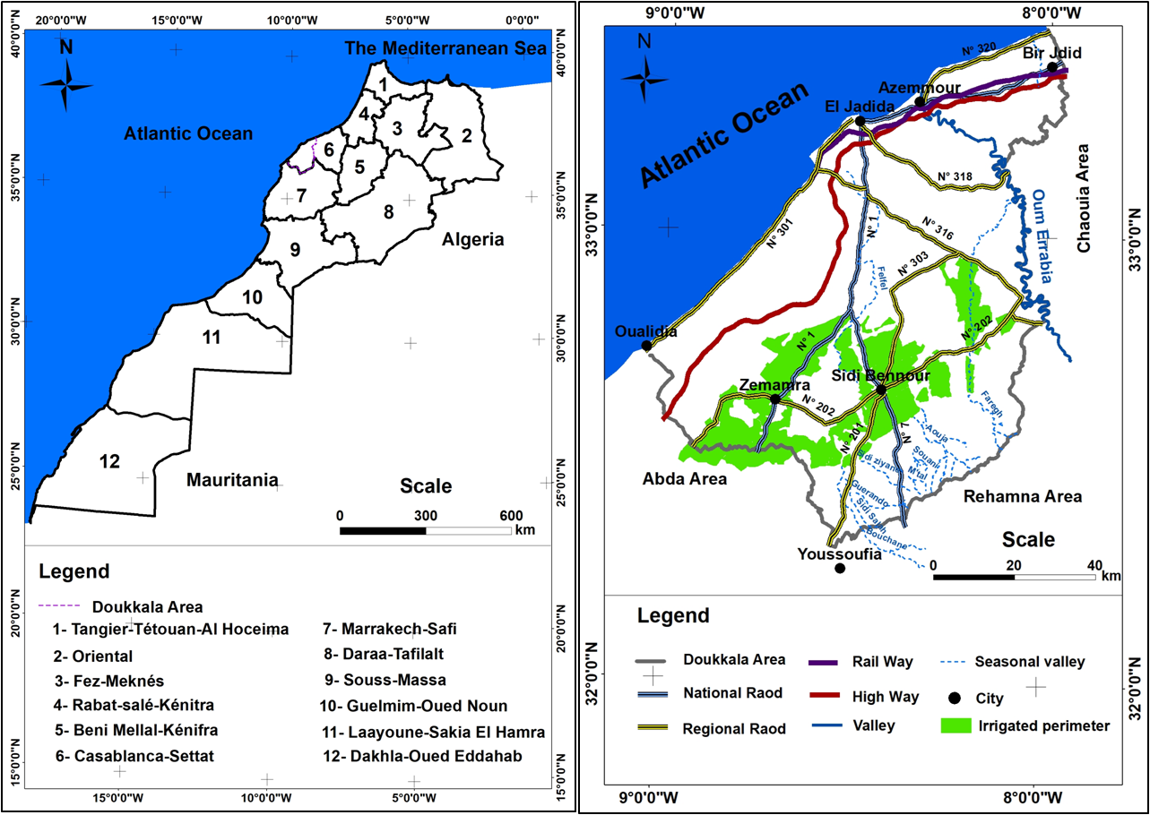
Figure. 1 Doukkala as an Area in the Region of Casablanca-Settat
The Doukkala is inhabited by 1.627 million inhabitants[[2]] and nine tribes: The Aounate, Ouled Bouzerara, Ouled Amrane, Ouled Amour, Ouled Bouaziz, Ouled Frej, The Haouzia, Chtouka, and the Chiadma[[3]](Figure 2). It approximately extents to 11289 km2. Doukkala is divided into two provinces: El Jadida and Sidi Bennour. The local population has interacted with the natural milieu of Doukkala, as it has adopted various traditional techniques and methods to cope with the scarcity of water resources and irregular precipitation in Doukkala. These techniques are actually used for achieving equilibrium in the economical and social sector and amelioration of living conditions.
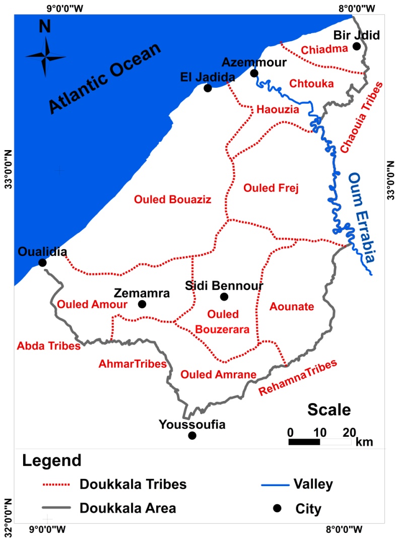
Figure. 2 Tribes of Doukkala Area
2.2 Data Source
This study is based on my PhD thesis research that has been supervised by the professors, Mohamed DAOUD and Ahmed LAKRADE in the department of geography. This study is based on field research to collect data after contacting the local population to identify various techniques and methods set to be used to cope with the local population with the nature of milieu, the scarcity and the practice cultivation types. This paper absolutely draws on scientific articles indicating several types of droughts and the index of droughts.
This paper is carried out to tackle all rainfall data covering a certain period of 33-year time, (1981/1982 a 2013/2014) from the meteorological station of Sidi Bennour city (Lat 32.6564 N° , E °8.4241Lng: – Alt:178 m) and the meteorological station the Koudia Center of Sidi Bennour city (Lat 32.7803 N° , E° Lng -8.4090 . Alt 177 m).
Using the methods Gaussen p≤2T°, Walter p≤3T° and Birot p≤4T° is to show the humid and dry months according to 33-year climate series. Using the software Arc Gis to create and produce thematic carts.
This paper directly draws on observing water management during the periods of precipitation. This terrain observation has been an opportunity to pick up pictures expressing how water management by the local population really is.
3. Methods
- Drought definitions and its types in Doukkala
- Drought definitions
The Drought is a complex phenomenon and is therefore defined in many ways; drought is a sustained period of below-normal water availability, so it is a recurring and worldwide phenomenon with spatial and temporal characteristics that vary significantly from one region to another[[4]]. Droughts are caused by a range of different processes including rainfall and snowmelt deficits or high evaporation[[5]]. Drought is a deficiency of precipitation over extended period of time resulting in water shortage.
- Drought climate
The drought climate occurs when dry climate conditions dominate a particular area. Drought climate is easiest to notice, and it is one that everyone knows it occurs when there is no longer any precipitation for a very long period of time. Drought climate is a measure of ecart precipitation deviating from what is normal.
The drought climate is a natural event and thus is the deficiency or the absence of precipitation in a particular area. It has consequences for agricultural production and vegetation cover and hydrology.
The Gaussen index is used to show the humid and dry months (Figure 3), to calculate the climate drought index for a 33-year climate series using the following method or equation:
p≤2T°
P: Mean monthly precipitation (mm)
T: Mean monthly temperature (c°)
Figure. 3 Climate Drought p≤2T° in Doukkala
The result of the figure 3 demonstrates that 5 months are humid and 7 months are drought according to the 33-year climate series; the climate drought is transferred to the hydrological drought.
- Hydrological drought
Hydrological drought events are driven by a variety of hydro-meteorological processes including lack of rainfall, snowmelt deficit or high Evapo-transpiration, whose importance varies with hydro-climate and by event severity[[6]]. Hydrological drought is a broad term related to negative anomalies in surface and subsurface water[[7]].
The walter index[[8]] is used to show the humid and dry months (Figure 4), to calculate the hydrological drought index according to 33-year climate series, using the method or equation that is to come:
p≤3T°
P: Mean monthly precipitation (mm)
T: Mean monthly temperature (c°)
Figure. 4 Hydrological Drought p≤3T° in Doukkala
The result of the figure 4 demonstrates that 3 months are humid and 9 months are drought according to 33-year climate series. The hydrological drought effects on agricultural activity and vegetation cover deteriorates, and its effect on the phreatic table or underground.
- Underground drought
Underground drought is associated with the climate and hydrological drought; it is the deficiency of water stratum or underground. It has consequences for domestic water irrigation of the wells to provide the cattle the natural need that is water.
The Birot index[[9]] is used to show the humid and dry months (Figure 5), to calculate the underground drought index according 33-year climate series using the method or equation that is to come:
p≤4T°
P: Mean monthly precipitation (mm)
T: Mean monthly temperature (c°)
Figure. 5 Underground Drought p≤4T° in Doukkala
The result of the figure 5 exhibits that all months are drought and the underground is fragile in Doukkala. The sustainability of this underground is related to other water sources should stay linked to the water catchment of the Oum Errabia basin. This catchment ensures sustainability of the agricultural activity and domestic water. The local population adopts various techniques and methods to adapt with the drought types and the natural milieu of Doukkala.
4. Characteristics of techniques used in managing surface water resources
Flood phenomenon depends on traditional techniques and methods in managing surface water resources[[10]]. The phenomenon constitutes complementary resources in agriculture activity to compensate the scarcity of precipitation. The flood area constitutes the important place of settlement of French colonizers before the year 1956. These French colonizers benefited from the water resources coming from Rehamna plateau as it practices different agriculture.
The flood area is located in the south-east of Doukkala, particularly in Aouja and Bouchane valley. The local population inherited some techniques from the French colonizers. It actually developed some techniques in terms of the forms, geometry and construction materials. In this context, it must be confirmed, that the flood phenomenon is located in the mountainous areas of Morocco (The Rif Mountains, High Atlas, Middle Atlas, Anti-Atlas). The scarcity factor was stimulated by creating this phenomenon in Doukkala, where the local population adopted various techniques and methods in management and mobilization of water resources.
4.1 Characteristics of techniques used in the Aouja valley area
The Rabta (local name) is a traditional technique used in managing water resources in the Aouja valley area. It is built transversely inside the valley. The Rabta diverts the water from the valley towards the agricultural exploitation for the irrigation. The Rabta takes different geometric forms according to the materials, topography and the nature of the valley. The Rabta is built in the form of a barrier with soil, stone material, cement materials and iron. The height of the Rabta between 3 and 4 meters and with about 10 meters according to the valley profounder and drain outfall )the form of a door( which closes and opens during the periods of the flood.
Historically, the Rabta is distinguished by its antiquity in the Aouja valley area. This technique was adopted by the French colonizer notably “Fautaine” for the management and mobilization the water resources. Using this technique by the French colonizer was compensated to reduce the scarcity in Doukkala (Figure 6). The colonizer, Fautaine built the first technique on the Aouja valley in the form of a soil barrier before 1956; this technique is named locally the Nasrani Dam.
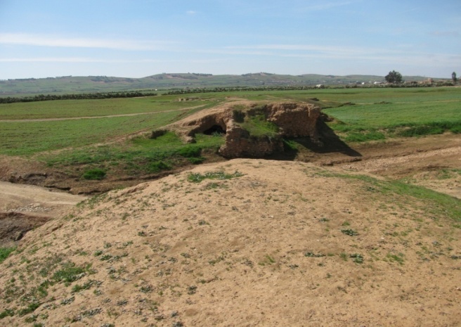
Figure. 6 The First Traditional Technique is Built on the Aouja Valley
After Morocco had got its independence in 1956, the French colonizer Fautaine abandoned agricultural exploitation in the Aouja valley area. But, the local population continued the same approach of managing water resources and developed the Rabta technique in terms of its construction, materials and geometric forms. The Rabta is a built individually or collectively between the farmers or the beneficiaries, it is considered an investment for the farmer from where the beneficiate and irrigation agricultural product. The rabta is known to be versatile in terms of the construction, the forms and the geometry (Figure 7).
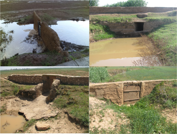
Figure. 7 Forms of the Rabta Technique
The rabta is considered to be a solid barrier to water inside in the valley, and it is characterized by the facility in the management and mobilization of the water resources. The Rabta distributes water from the valley to the agricultural exploitation.
The Hancha (local name) is a traditional technique used in managing water resources in the Aouja valley area; it is used to distribute water between the farmers. This technique is built by soil or cement materials taking various geometry forms. The Hancha is built individually or collectively by the famers (Figure 8); this technique distributes and shares water for the irrigation agricultural production.
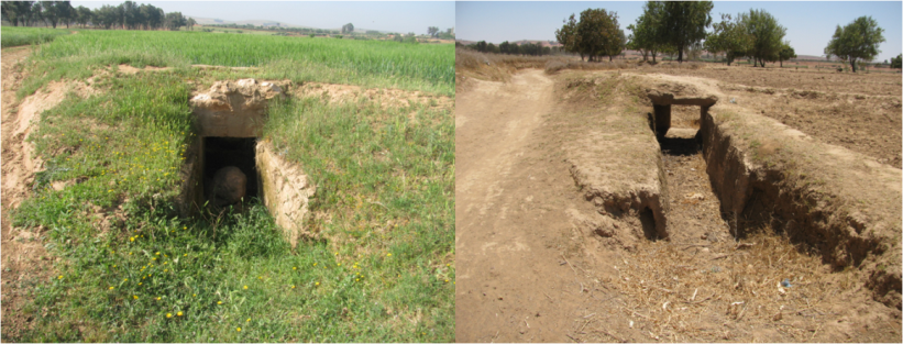
Figure. 8 Forms of the Hancha Technique
4.2 Characteristics of techniques used in the Bouchane valley area
The figure 9 shows the first traditional technique in Bouchane valley area; this technique is used by the French colonizer before 1956. The technique is built to form barriers (Figure 9) made of cement and iron. It distributes water from the Bouchane valley to the agricultural exploitation for the irrigation operation .

Figure. 9 The First Traditional Technique is Built on Bouchane Valley
The French colonizers developed the techniques during the protectorate in Morocco; these colonizers benefited from the Morocco state in terms of the equipment operations. Developed techniques are characterized in terms of the forms, materials, and the geometry:
The Sakia (local name) is a traditional technique used in managing water resources in the Bouchane valley area. This Sakia was built by the French farmers which takes its source from first ancient technique. The Sakia is built by the soil; it distributes the water from valley to the agricultural exploitation (Figure 10).
The state of Morocco was intervened during 1996 in Bouchane valley; it built a modern hydraulic technique (Figure 11). This modern technique distributes the water a rate 70 m3 per second. The Sakia technique transfers the water from the modern technique hydraulic to the agricultural exploitation.
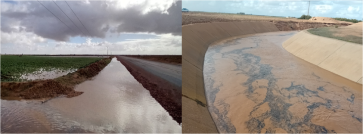
Figure. 10 The Sakia Technique in the Bouchane Valley
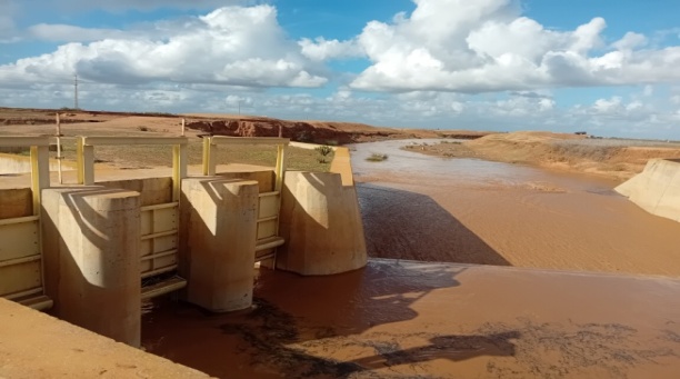
Figure. 11 Hydraulic Modern Techniques on the Bouchane Valley
The Karaja or water intake (local name) is a traditional technique used in managing the water resources in the Bouchane valley area. This technique was actually adopted by the French colonizer. It was built individually or collectively using cements and iron materials on rivers of the Sakia technique. The Karaja is homogeneous when it comes to what is geometric with 40 to 50 centimetres and length 3 to 5 meter (Figure 12). This technique distributes the water from the sakia to the agricultural exploitation for irrigation agricultural production.
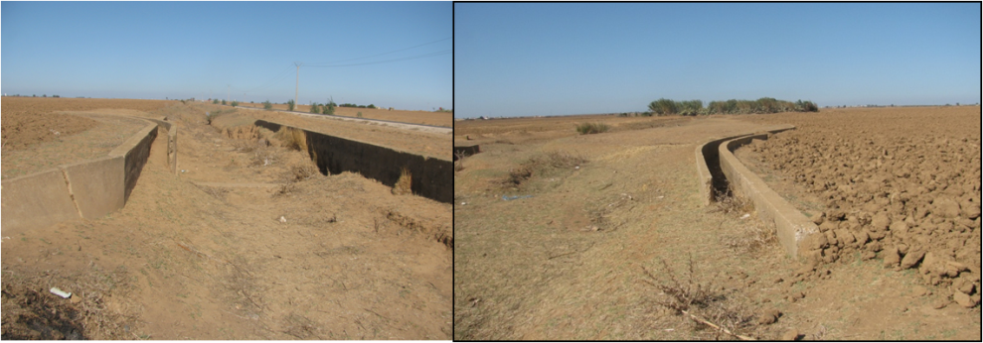
Figure. 12 The Karaja Technique in the Bouchane Valley Area
The local population has developed various techniques and methods in the Aouja and Bouchane valley, and it is maintained on the sustainability of water resources and the traditional techniques in the semi-arid Doukkala.
4.3 Method Distributions and Management of the Water in the Aouja and Bouchane Valley
The farmers distribute water in the Aouja and Bouchane valley for irrigating the agricultural exploitations. The water distribution is meant to be alternative for the purpose of guaranteeing a normal management of the water resources (Figure 13). The method of distribution draws on solidarity and cooperation between the farmers; they distribute he water without any leader or sheikh of water (local name) such as in oasis areas.
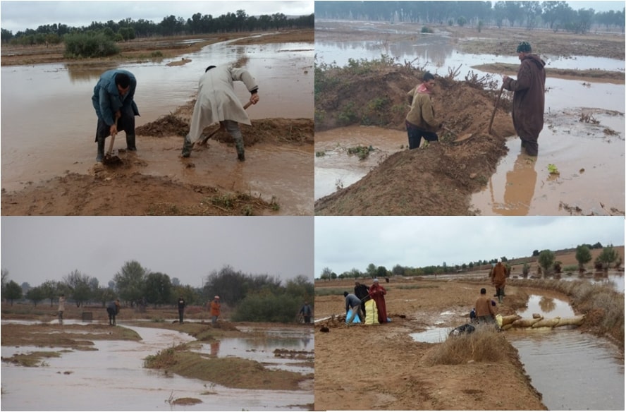
Figure. 13 Distribution of the Water between the Farmers
The farmers distribute water from the valley and sakia to agricultural exploitation. This distribution is collective (farmers group) and individual (Figure 14).
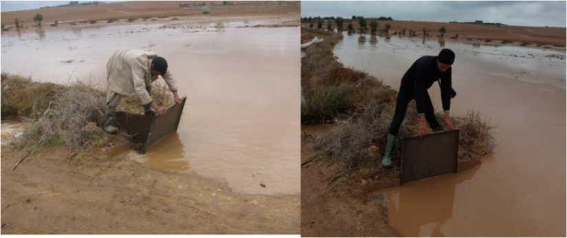
Figure. 14 Farmer Opening the Door of the Hancha Technique
Doukkala is characterized by the scarcity and semi-arid climate; the local population is to cope with the water in case the scarcity and abundance in the Aouja and Bouchane valley area:
– In case of the scarcity, the farmers share water equally to water their allotment.
– In case of the abundance, all the farmers benefit from water. After the irrigation operation, the farmers abandon the water in valley naturally.
This technique and this method are characterized by simplicity and the efficacy in Doukkala fragile. The result, these techniques are contributed to compensate for the water deficiency in the agricultural sector.
5. Characteristics of the Techniques Used in Managing the Water Underground.
The traditional management draws on the water underground; it is located in the rivers of the Islan valley in Ouled Jarrar (Doukkala south-east), this irrigation depends on the techniques and traditional methods. The traditional irrigation depends on the digging well named locally (the Aghrour well), this well is used by the local population for agricultural irrigation and exploitation and domestic water to water the cattle (Figure 15). The Aghrour is a traditional well dug by the stones and soil materials; these wells are dug off the Islan valley with the use of the traditional tools.
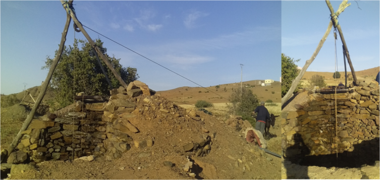
Figure. 15 Characteristics of the Aghrour Well
The bucket is a traditional technique used in managing the water; it is used for raising the water from the wells. The animals are used to pull the bucket from the Aghrour well; it is made of animals skin, but at the moment, the bucket is made of rubber recycles from the car tires, as it takes a longitudinal geometric form.
This bucket is an effective technique (Figure 16) used in the management of water; it distributes water from the well to the agriculture exploitation.
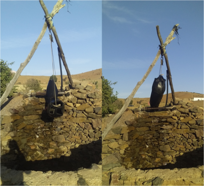
Figure. 16 Characteristics of the Bucket Technique
The local population manage the water according to the slope factor in the irrigation. It is a mobilization in a specific place named locally “The basin” which is built above the well. The basins distribute the water to the agricultural exploitation according to the slope factor.
6. Characteristics of the Traditional Well in Doukkala Area
The local population adopt various management forms for providing domestic water[[11]] and to water the cattle. The local population dig the traditional wells to alleviate the droughts and the scarcity of the water resources. The traditional well is related to the Douar (housing group), so that each Douar is digging the well, each well gets the name of the Douar. The well is dug traditionally and collectively using the techniques and methods in the digging operation. The well is paved by stones, soil materials, cement and iron – this is called drilling; the drilling operation takes a long time for about a year.
The traditional wells consist of the pulley techniques fixed on the pillars, and it consists of the place or basin to water the cattle and the basin to mobilizing the domestic water (Figure 17). The local population use the bucket for raising water from the well, and thus it uses animals to pull the bucket.
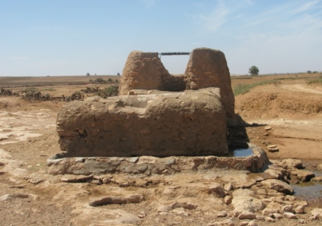
Figure. 17 Characteristics of the Traditional Well in Doukkala Area
The local population adopts methods to manage the well water, so each family gets their share alternatively. This is actually based on respect to avoid the conflicts between the beneficiaries, especially during the summer or during water demand augmentation. The local population use the traditional means for transportation when transferring water.
The Adal (local name, made of tire rubber) is a traditional means used in transferring water from the well to the house (Figure 18). This means it is carried on the back of draft animals such as a donkey or a mule. The local population use the barrel means (Figure 19) which is carried on the traditional cart. The well water is exploited for domestic purposes, washing and to water the cattle, and it is exploited in the irrigation some plants such as mint, olives and the figs.
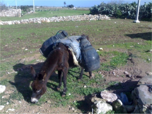
Figure. 18 The Adal Means for Transferring the Well Water in Doukkala
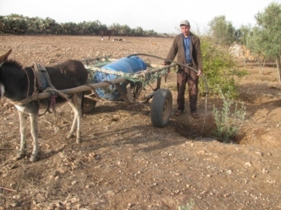
Figure. 19 Barrel Means for Transferring the Well Water in Doukkala
Doukkala area has witnessed a transformation in domestic water, where it is transformed towards the modern management and mobilization of water, these modern managements are based on digging wells which use the fossil, electrical and solar energy. The Moroccan state is intervened in providing the local population for potable water, and it creates associations to manage the potable water in Doukkala. The local population has not abandoned the traditional well, but exploitation has become very limited in Doukkala. The traditional well constitute a material heritage; it must not be neglected and preserved in semi-arid Doukkala.
7. Characteristics of the Natfiya Technique
The Mediterranean basin constitutes a place to chasse water on the precipitation surface using the Natfiya technique in cases of the abundance and scarcity. The Natfiya takes various names in the countries of the Maghreb such as: The Tabya, the Ghadir and the Natfiya in Morocco.
The Natfiya (local name) is a traditional technique used in managing the water resources; the local population use the Natfiya to store and mobilize water (Figure 20). The Natfiya is an underground store taking several geometric forms cylindrically, conically and rectangular. The Natfiya is dug in a slope to collect and chasse water coming in the roads, or it is dug inside the house to collect or chasse water fallen above the houses during the periods of precipitation.
The digger use traditional tools in the digging operation such as pickaxe, shovel, ropes and the bucket; the depth is chosen according to the geometric form between 5 and 6 meters for the rectangular forms, the exterior form of the Natfiya is built by stones, soil and cement, and the door to protect the Natfiya from the animals, and the storm drain is used for the mobilization of precipitation of water, the interior form of the Natfiya is paved using a mixture of sand and cement to prevent water damage.
Distinguishing between two Types of the Natfiya Technique:
– Fresh Natfiya is built inside the house to receive water from the terraces of the houses; it is characterized by the quality water which is used as potable water and domestic purposes.
– Dirty Natfiya is built on the sides of roads and inside houses; it is characterized by the low quality water which is used in to water the cattle and irrigating the tree and the plants.
Distinguishing between two Types in Terms of the Legal Status:
– Collective Natfiya is exploited commonly by all the families of the Douar; it is built in centre of the Douar in a public place.
– Individual Natfiya is exploited by the family; it is built inside house or outside house which is used in domestic water and to water the cattle.
The Natfiya is related to the precipitation in cases of the abundance and scarcity:
– Abundance cases: the Natfiya secures the water reserve, and it provides the water the local population need.
– Scarcity cases: the Natfiya gets a decreased storage of water; the local population resort water from wells using cisterns means for the mobilization or assuring the water reserve.
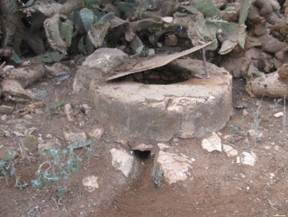
Figure. 20 Characteristics of the Natfiya Technique in Doukkala
8. Characteristics of the Oglat Technique
Doukkala is well known by diversity in the management of water resources, this diversity is based on the use of the ancient inherited technique which is adopted by the local population in semi-arid Doukkala. The Oglat (local name) is an ancient traditional technique used in managing water underground (Figure 21). The Oglat is indicated to a well which depth varies between 5 and 10 meters[[12]] in fragile milieu, it is a related to the phreatic table or underground which is alimented to the precipitation or rainfall. This traditional technique is diffused in east Doukkala especially in the territorial commune Tamda, Mtal, Jabria and Khmis ksiba.
The local population use traditional tools in digging the Oglat such as pickaxe, shovel, ropes, the bucket, etc. The exterior part is built by dust, stones, cement, and watershed part to water the cattle. The interior part is built by stones and paved with cement. The local population uses the bucket for raising the water from the Oglat using human energy.
The Oglat is similar to the Natfiya in the exterior part when it comes to the geometric form, but they differ in terms of the alimentation source, that the Natfiya is related by collecting the precipitation water while the Oglat is a related to the underground.
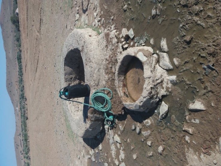
Figure. 21 Characteristics of the Oglat Technique
9. Discussion
The result is that Doukkala is categorized within the semi-arid climate; it is characterized by fragile underground owing to the dominate drought climate. On the other hand, the hydrological drought is associated with the impact of water resources to meet water demand and ecological. The local population is adapted and interacted with the characteristics of the Doukkala milieu, as it creates various traditional techniques and methods for managing water resources.
The local population practice agricultural activities which vary in terms of quantity and quality such as barley, wheat, beans and maize, the rentability of each one hectare of barley is varied between 30 and 40 quintals in the Aouja and Bouchane valley area, but in the Bour areas, the rentability of each one hectare of barley is varied between 10 and 20 quintals.
The Aghrour well is a traditional technique used in the management of water underground, it is contributed to reduce water scarcity in Ouled Jarrar area which consists of hills and fragile lands. The local populations make use of the micro exploitation which is named locally “the agricultural bench”; its spacial area does not exceed 1000 square meters. The agricultural bench is exploited in cultivation that is of great economic importance to the local farmers in Ouled Jarrar area such as mint and alfalfa and the coriander.
The Oglat is a traditional technique used in the management of water underground in semi-arid milieu. This technique contributes to reduce water scarcity and ensure water providing especially domestic water and to water the cattle.
The Natfiya is a traditional technique used to collect or chasse water precipitation for the storage and mobilization of water. The Natfiya is an adequate solution to cope with the milieu nature of Doukkala; it contributes to reduce water scarcity. The water of Natfiya is used in various purposes such as domestic water, to water the cattle, irrigating some trees such as olives, figs, and some cultivations such as mint and so on.
Conclusion
Doukkala is characterized by semi-arid climate and the scarcity of water resources, as it is characterized by the dominant climate, hydrological and underground drought. The local population is adopted with the nature milieu of Doukkala; it adopts various traditional techniques and methods to manage water resources. This technique is characterized by the simplicity, efficacy and its ancient nature. It consists of the adequate solution to cope with the fragile milieu and to reduce scarcity water and ensure the stability of human.
The technique adopted contribute to the providing of domestic water, to water the cattle, and irrigating the various cultivations particularly in the Aouja and Bouchane area; this technique contribute to the stability of human and the economic amelioration and social situation of the local population.
But these techniques adopted expose a lot of constraints:
– The Rabta and Hancha technique expose the degradation and abandoning some techniques by the farmers, and immigration factors by young people so that the results neglect this technique.
– The Natfiya technique exposes the accumulation of materials, and hiding of the Natfiya driller.
– The traditional well expose the water depletion of underground and orientation to modern management so that results neglect wells.
– The Oglat technique and the Aghrour well expose the depletion during precipitation reduction and abandonment of some technique because the immigration factors so that the results neglect this technique despite its effectiveness in management and mobilization water resources.
References:
- [] The Meteorological Station Koudia the Center and Sidi Bennour City, (1981/1982 à 2013/2014. ↑
- [] Recensement général de la population et de l’habitat – Maroc, (2014). ↑
- [] Michaux, B. Villes et Tribus Du Maroc: Les Doukkala, Volume. X, Tome. I, Présentation BOUCHAREB Ahmed, Publications de la faculté des lettres et des Sciences Humaines-, 1ére édition 2012,p 159 , Rabat, (1932). ↑
- [] Anne, F. Van, L. Hydrological drought explained, Overview, Wires water, pp 1-34, (2015). ↑
- [] Manuela, I, B. Janas, G. Christopher, S. Anne, F. Van, L. Hydrological drought generation processes and severity are changing in the ALPS, Geophysical research letters, AGU, pp 1-16, (2023). ↑
- [] Manuela, I, B. Janas, G. Christopher, S. Anne, F. Van, L. Hydrological drought generation processes and severity are changing in the ALPS, Geophysical research letters, AGU, pp 1-16, (2023). ↑
- [] Anne , F. Van, L. Hydrological drought explained, Overview, Wires water, pp 1-34, (2015). ↑
- [] Gaussen, H. l’étude des climats par les courbes ombrothermiques: application à la cartographie, Persée. In: l’information géographique, volume 20, n° 5, 1956. pp 191- 193, (1956). ↑
- [ ] Medjerab, A. Cours de Bioclimatologie, Spécialité: Climat-Environnement (LMD), Université des sciences et de la Technologie Houari Boumediene, Faculté des sciences de la terre, de géographie et d’Aménagement du Territoire, pp 1-57, (2013). ↑
- [ ] Mohammed, B. Youssef, E. Hassan, O. Ahmed, L. Résilience et formes d’Adaptation des agriculteurs face aux risques hydro climatiques : le sud-est des Doukkala comme exemple, Actes du colloque international sur la vulnérabilité des territoires face aux risques hydro climatiques, Faculté des lettres et sciences humaines, Université Mohammed 1er – Oujda, p 149- 155, (2021). ↑
- [ ] Mohamed, B. Les modes d’approvisionnement et de consommation de l’eau dans les compagnes des Doukkala: Quelques aspects des changements socio-spatiaux, mutations socio spatiales dans les compagnes marocains. Université Mohamed V publications de la faculté des lettres et des sciences humaines. Rabat, série colloque et séminaires, page 53,(1994). ↑
-
[] Ferre, M. Ruhard, J. Ressources en eau du Maroc plaines et bassins du Maroc atlantique, Les bassins des a Abda- Doukkala et du Sahel de Azemmour a Safi” Tome 2, Edition du service Géologie du Maroc, Rabat, page 283,(1975). ↑
